|
Sat Jan 14th & Sun Jan 15th -- FDR State Park
Registration & Check in
Friday -- Packet pick up will be avaiable from 5:30 pm - 8:00 pm at the Mountain Creek Inn at Callaway Gardens -- 17800 US-27, Pine Mountain, GA 31822
Saturday -- Packet pick up will be available from 9:00 am - 11:00 am at Meet HQ Sunday -- Packet pick up will be available from 8:00 am - 10:00 am at Meet HQ MapsMap is at 1:10,000 scale with 5.0 meter contours, except F21+ and M21+ which will be 1:15,000
Courses
RestroomsPorta toilets are available near Meet HQ and in the Liberty Bell Pool parking lot
Parking
All passenger vehicles must have a state park parking pass. Car parking costs $5/day
The park manager will let you pay for multiple days with one envelope, punch out the squares for the days you pay for Passes can be found near the southern end of the Liberty Bell Pool parking area. You risk a ticket without a parking pass School buses may park without a pass Practice MapWill be available at packet pick-up and for download here
Clothing ReturnClothing will be returned from the start line to Meet HQ as quickly as we can
Walk to Start
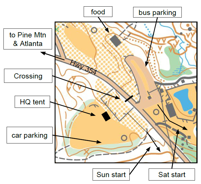
Saturday walk will take 5 to 10 minutes from Meet HQ
Sunday walk will take 20 to 25 minutes from Meet HQ and will involve approx. 50 meters of climb. Course Notes
FDR Mapper: It would be hard to find a more open forest in the southeast than the north side of Pine Mountain. The mountain itself is steep near the top, with reentrants large enough to hide everyone attending this meet with room left over. On the lower slopes the terrain becomes more gradual and subtle.
There is some mountain laurel, which is rare to find this far south - a leftover from the last time we had climate change. This is mapped in green along the stream beds, but it is easy to get through. The leaves are deep this time of year and can be slippery on the steep slopes. There is also some loose rock in places hidden beneath the leaves. The hiking trails are easy to see. The horse trails on day one are not, although they are blazed on the trees. This map is where orienteering began in Georgia over 30 years ago.
FDR Course Setter: Point features are relatively rare in certain areas of the park so features as small as one half meter may be used for control locations. All point feature control descriptions include the height of the feature. Most mapped boulders are fairly small and are mapped with a small boulder symbol; the few larger boulders are mapped with a larger boulder symbol. Boulder clusters are mapped with a scalene triangle symbol as depicted on the map legend. Root stocks are common and mapped as a brown ‘x’; only those more than one half meter tall and with dirt on the root ball have been mapped as consistently as possible. Those that no longer have a significant tree trunk or roots but still have at least a half meter of dirt are mapped as a dirt pile/small knoll.
Saturday courses begin about a 5 minute walk from Meet HQ, have climb early in the course, and end on the flatter area of the map. Route choices may include a few small creek crossings, but should not require getting wet. Handrails for the White and Yellow courses will include small streams and ditches in addition to trails. The Yellow course will have blue flagging tape to follow on a few legs. No courses cross any roads; however, if you choose to run along any road, please pay attention to cars traveling on the road and give them right of way. Some of the trails on the Saturday map are open to horse riders; the courses have been designed so that these trails are not optimal route choices. If you do encounter any horse riders on the trails, please give them right of way. Safety Bearings for Day 1: Head South until you reach Highway 190 or Southwest until you reach Highway 354. The Sunday start will require an uphill walk of approximately 25 minutes from Meet HQ. Sunday’s map has several abandoned road beds that are mapped as “rides”. The White course uses one of these “rides” as a handrail, along with trails, small streams, and ditches; several legs will have blue flagging tape to follow. Orange and Advanced courses require crossing the road that runs between the park office and Lake Delano. Please use caution when crossing this road and give any cars traveling on the road right of way. Campgrounds and park cabin sites are out of bounds and must be avoided. Safety Bearings for Day 2: Head South until you reach Highway 190 or the road between the park office and Lake Delano or head East until you reach Highway 354. |
||||||||||||||||||||||||||||||||||||||||||||||||||||||