|
Friday Jan. 13th -- McIntosh ReserveSite Map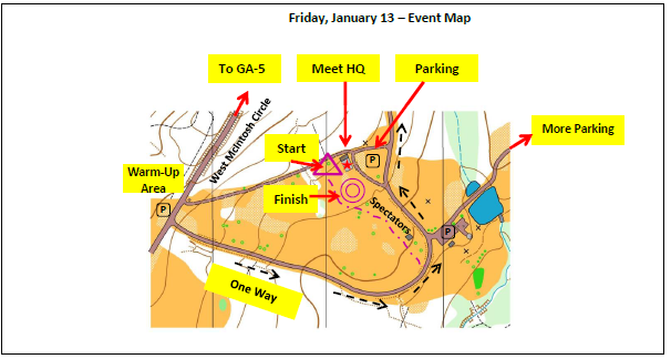
Registration & Check inPacket pick up will be available from 1:00 pm - 3:30 pm at Meet HQ
MapsMap is at 1:5,000 scale with 2.5 meter contours, ISSOM standard
RestroomsRestrooms are available in the small building SE of Meet HQ
Warm up / Practice map
A small practice area is located to the west of Meet HQ
Practice maps will be available at Meet HQ. Model course will open at 12 noon. Clothing ReturnNo clothing return is provided because start is close to parking and Meet HQ
Spectator Area
We will be taping off a section of the field so spectators will not interfere with runners
Please be mindful of the taped area Course Notes
We will be set up in an open field, with easy access to start and finish.
There are also spectator controls in the field for your enjoyment. Wave when you go by!
There is a one-way loop road that circles past the practice area and the start/finish. Do not walk to the practice area through the field where the start and finish are located. Drive or walk along the road, in the correct direction. McIntosh Reserve: McIntosh was a chief of the Lower Creeks. His mother was a Creek, his father Scotch-Irish. The Creeks occupied most of Middle Georgia and Alabama, and were under pressure to move west from the US settlers. McIntosh negotiated a treaty in 1825 that ceded almost all the creek lands in Georgia in exchange for cash payments. One exception was a small reserve along the Chattahoochee River that was deeded to Chief McIntosh - which we know now as McIntosh Reserve. The Creeks were not happy with McIntosh, and other Creek chiefs seized and executed him in 1825. He is buried in McIntosh Reserve, not far from control #125 on the Sprint A course. |