|
GNC / SEIS
Sat Jan 14th & Sun Jan 15th -- Mistletoe State ParkSite Map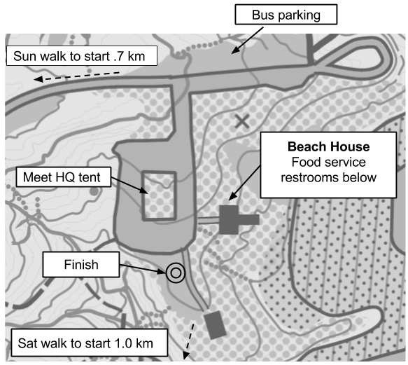
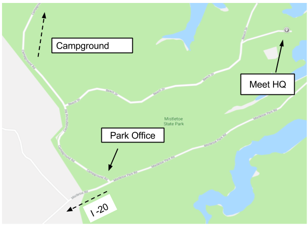
DirectionsPark address is 3725 Mistletoe Road Appling, GA 30802GPS: 33.643283, -082.385200 Directions Registration & Check in
Friday -- Packet pick up will be avaiable from 5:30 pm - 8:00 pm
Hampton Inn Thomson GA 1702 Washington Road, Thomson GA 30824 (706) 595-5300 Saturday -- Packet pick up will be available from 9:00 am - 11:00 am at Meet HQ Sunday -- Packet pick up will be available from 8:00 am - 10:00 am at Meet HQ MapsMap is at 1:10,000 scale with 3 meter contours, except F21+ and M21+ which will be 1:15,000
EmbargoPark is embargoed April 1, 2017
Courses
Jan 13th and 14th -- Recreational Map Hikes
A limited number of non-competitive Orienteering spaces are available on a beginner's level course.
Beginner instruction will be available. The Map Hike will NOT be the same as any competitive course. Register at the Meet HQ Saturday 10:00 am – 1:00 pm, must return by 3pm, Sunday 10:30 am - noon, return by 2pm. $10 per map, $3 per extra map. Map Hike will use manual punching. Restrooms
Portable toilets are available near Meet HQ
Restrooms are located below the "Beach House" food service building Parking
All passenger vehicles must have a state park parking pass. Car parking costs $5/day
Passes will be available at Meet HQ on Saturday. You will need a pass for each day you are in the park You risk a ticket without a parking pass School buses may park without a pass Practice MapWill be available at packet pick-up
The model map is just north of the “Beach House”
Practice course opens 3 pm Friday Jan 12th and closes noon Sunday Jan 14th
Clothing ReturnClothing will be returned from the start line to Meet HQ as quickly as we can
Walk to Start
Routes are marked with blue flagging tape
Saturday walk is about 1,000 meters from Meet HQ Sunday walk is about 700 meters from Meet HQ Course Notes
Mapper's Notes:
Mistletoe and Hard Labor Creek State Parks, between Atlanta and Augusta, are typical examples of Southern Piedmont terrain with erodible soils exposed to intensive farming in the 19th and first half of the 20th centuries. The result is a complex of ditches, gullies and ravines that will continue to erode despite being long since covered by vegetation. For orienteering purposes, they are relevant to runnability and navigation, and are mapped as linear features so that information may be depicted between the 3 meter contours. They are the salient feature of these orienteering maps.
The brown dotted lines are dry ditches that break the ground surface, are easily crossed and noticeable at normal speed. Gully lines (pointed at both ends) are deep, narrow ditches one to three meters deep, that will cause the runner to slow/stop to cross. Ravines are enclosed by the earth bank line (often without tags if too narrow) and are 2 meters to 6 meters deep and are not easily or safely crossed. Ravines that are dangerous/forbidden to cross are marked by the black cliff symbol with taglines.
Rock features are not abundant and are mapped if they are noticeable within 30 meters of the runner, regardless their absolute size. Cliffs are rare so most rock outcrops are mapped with the crossable cliff symbol (thick black line without tags) and most identifiable from the downhill side so they are drawn parallel to the contour line. It is interesting to note that most of the rock outcrops on these maps are shaped like half a hot dog and oriented in a SW-NE direction with the rounded end most visible on the downhill side when the contour runs perpendicular to it. Clusters of these boulders make for interesting control locations. Boulders visible from all sides are mapped with a corresponding size black dot. There are numerous low rock piles and are depicted with a small irregular triangle. The cairn/boundary symbol has been reserved for boundary markers. The black circle depict junk piles and the black X is a permanent man made feature.
Most rootstocks (green X) are at least a meter high and there are some new ones that may not have been observed. There are old rootstocks that have eroded below one meter and may or may not still be marked. These may have degraded to the brown dot knoll if they are noticeable at a 30 meter distance. Brown dot knolls are common along old road beds (narrow ride line) and are not all mapped and the small brown dot symbol (broken ground) indicate clusters of dirt piles. The green dot symbol is reserved for the Hardy Orange, an introduced species with an impenetrable growth habit, that is slowly spreading in the park.
Clark's Hill Lake is low at Mistletoe State Park and the exposed shore is runnable and marked as rough open (light yellow) and wide green lines indicating slow running. The black bank line indicates the normal level of the lake and is crossable.
Blue magnetic north lines are 250 meters apart at map scale.
Green runnability is marked according to winter time conditions. Visibility/runnability changes dramatically during warmer times of year.
Setter's notes:
Many gullies, ditches, and reentrants are used as control locations, and they can look similar on the ground. Be sure to check control codes! Point features as small as one half meter may be used for control locations; all point feature control descriptions include the height of the feature. Campgrounds, park cabin sites, and ranger residences are out of bounds and must be avoided. As mentioned in the mapper’s notes, the lake is low, and the exposed shore is runnable; you are allowed to run or walk in the dry part of the lake bed.
The Saturday start requires a walk of approximately 1000 meters from Meet HQ; the route is flagged with blue flagging tape. The first few controls on White and Yellow courses are near the lake; use the edge of the lake bed as a handrail. The White course has one leg flagged with white flagging tape. The Green, Red, and Blue courses have creek crossings that may get your feet wet. Pay close attention to the map to find the best creek crossings. All courses have at least one road crossing; please pay attention to cars traveling on the road and give them right of way. Safety Bearing for Saturday: Head North until you reach the road or the lake.
The Sunday start requires a walk of approximately 700 meters from Meet HQ; the route is flagged with blue flagging tape. The White course has two legs flagged with white flagging tape. Orange, Brown, Green, Red, and Blue courses cross an intermittent stream that may or may not get your feet wet. The banks of the intermittent stream are steep; pay close attention to the map to find the best creek crossings. All courses have at least one road crossing; please pay attention to cars traveling on the road and give them right of way. Safety Bearing for Sunday: Head Southeast until you reach the road or the lake.
|