|
Home
Big Peach Discount
COVID rules
Race Info
Friday
Sat / Sun
SE Interscholastics
Schedule
Registration/Fees
T-shirt
Lodging/Travel
Accommodations
Tourism
Volunteers
Contacts
Meet Guide
Mixed Punching
  Georgia Orienteering Club
 NATIONAL RANKING EVENT
 WORLD RANKING EVENT
|
Friday Jan 14 -- University of West Georgia
GAOC is implementing special COVID rules for event participants to maintain the health and safety of all participants and volunteers and to comply with state and local laws and park regulations. By entering in and attending the event you are agreeing to abide by these rules. Please make sure you read and understand them
In particular, please read, understand and comply with the rules on Masks, Social Distancing, Start, Finish and Results.
There will be NO water on the course. There will be NO food or water at the finish. Please plan accordingly.
Participants should NOT attend if they feel unwell, have a fever, have recently been exposed to COVID-19 or should be in quarantine for any reason
WRE Runner Instructions
Start times
All WRE runners will be assigned start times approved by the IOF Advisor according to IOF guidance. Start times MAY NOT be requested and MUST be adhered to. There will NOT be a punching start for WRE runners. Their time will start at their assigned start time. WRE runners that arrive late will be started as soon as is practical according to IOF guidelines. Their start time will only be modified in the case that there is a valid and verifiable reason for arriving late
W21 control descriptions are 144mm x 46mm and the M21 control descriptions are 155mm x 46mm.
Men's start times will be every minute from 2:00 pm until 2:17 pm
Women's start times will be every minute from 2:22 pm until 2:32 pm
General Information
Location
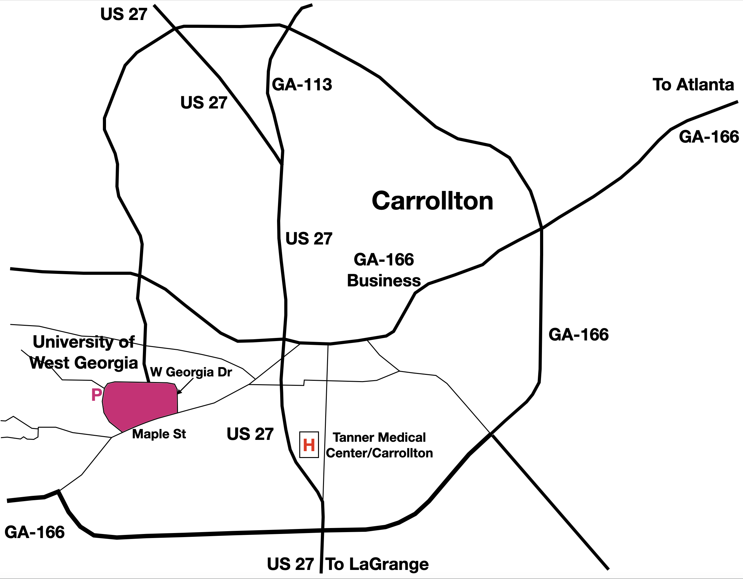
Click map to open in a new window
Address: Intersection of Stadium Dr and West Georgia Dr, Carrollton, GA 30118 (Parking in Lot 17 off Stadium Dr)
Parking Lot 17 coordinates are 33.574834259564255, -85.10531641650947/33°34'29.4"N 85°06'19.1"W
Typically 55 mins - 1 hr 30 mins drive from Atlanta International Airport Rental Car Center on Friday mornings
University of West Georgia Maps and Directions website
*** Please obey the campus speed limits at all times ***
Site Map
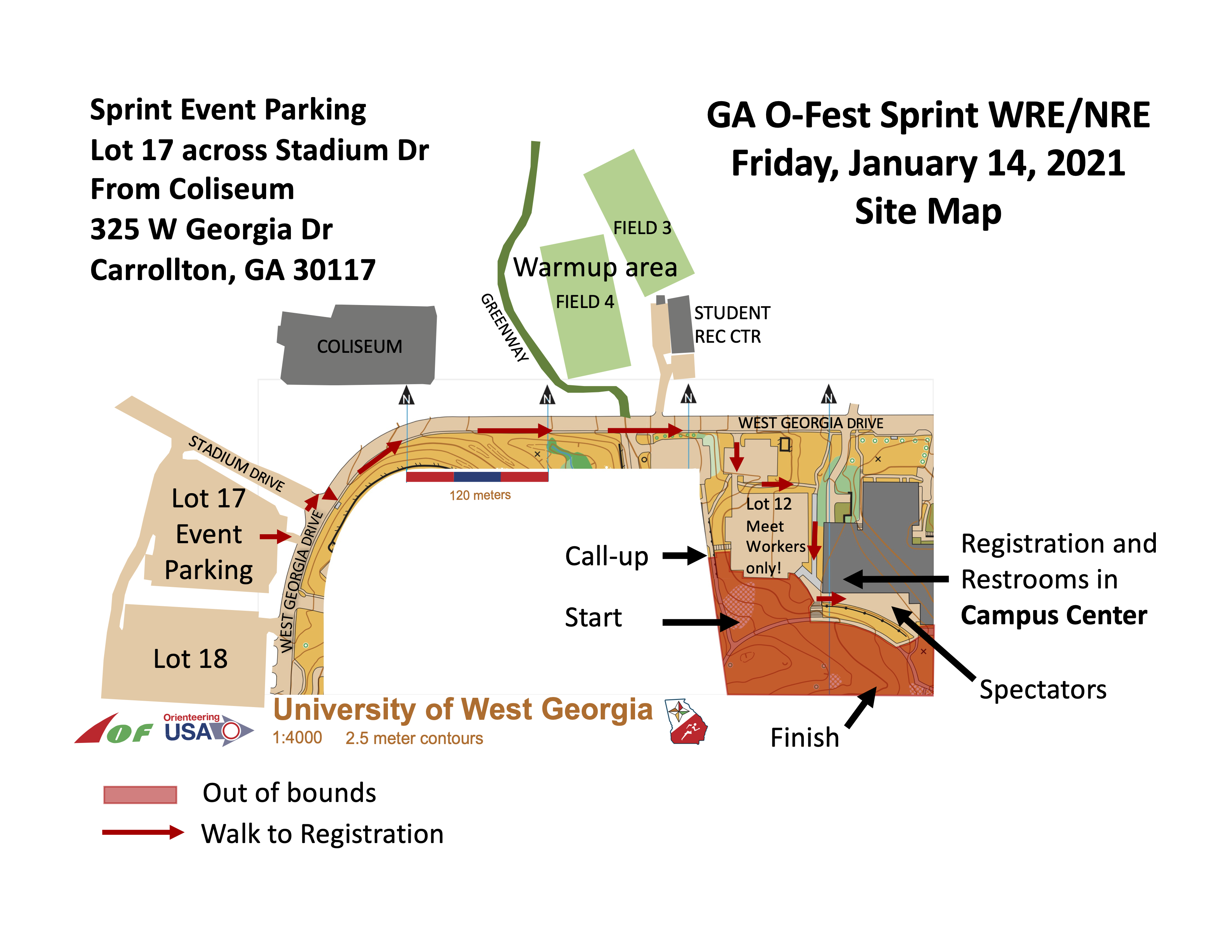
Click map to open in a new window
Meet HQ
Campus Center, University of West Georgia.Walk around the campus along W Georgia Dr from Lot 17 to Lot 12 then south through Lot 12 to the Campus Center.
No studs or cleats of any kind are allowed in any buildings!
Registration & Check in
Packet pick up will be available at Meet HQ from 1:00 pm - 4:00 pmStarts
Starts will be from 2:00 pm - 4:30 pm. Maximum Time is 1 hour. Courses close 5:30 pmThe first WRE start will be at 2:00 pm
The first NRE start will be at 3:00 pm
Maps
Map is 1:4,000 scale with 2.5 meter contours, ISSprOM 2019 standardEmbargo
UWG Campus is embargoed from June 1, 2021The University of West Georgia ISSOM map from the 2016 meet is available here
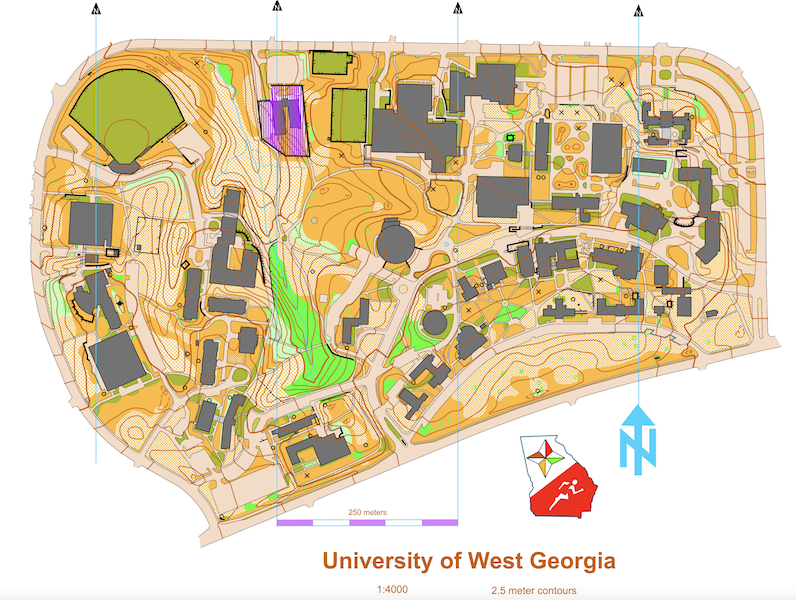
Click map to open PDF in a new window
Courses
| Course | OUSA/WRE Classes | Dist/Climb/Cntrls |
|---|---|---|
| White | F-10, F-12 M-10, M-12 M/F White, Grp White | 1.3 km / 45 m / 12 |
| Yellow | F-14, M-14 F Yellow, M Yellow, Grp Yellow | 1.5 km / 50 m / 13 |
| Orange | F-16, M-16 F Orange, M Orange | 2.0 km / 70 m / 17 |
| Brown X | F-18, F55+, F60+, F65+ M65+, M70+, M75+ | 2.3 km / 75 m / 18 |
| Brown Y | F70+, F75+, F80+, F85+, F90+ M80+, M85+, M90+, F Brown, M Brown | 1.6 km / 55 m / 13 |
| Green X | M-18, M50+, M55+, M60+, M Green | 2.6 km / 90 m / 20 |
| Green Y | F-20, F35+, F40+, F45+, F50+, F Green | 2.4 km / 80 m / 16 |
| Red | F-21+, M-20, M35+, M40+, M45+, M Red | 2.9 km / 90 m / 18 |
| Blue | M-21+ | 3.4 km / 100 m / 22 |
| W21E | W21 | 3.3 km / 90 m / 20 |
| M21E | M21 | 4.0 km / 115 m / 22 |
Restrooms
Restrooms are available at the meet HQ in the Campus CenterNo studs or cleats of any kind are allowed in any buildings!
Cell Phone Service
Cell phone coverage is generally goodParking
Parking is in Lot 17. Entrance is from Stadium Dr near the intersection with W Georgia DrPractice map
There will be no practice mapBabysitting
Babysitting will not be provided. Please do not plan on just leaving your young child at the Meet HQ. Please let the Registrar know if you have special start time requests that would help your own child care arrangements
Emergency Information
In the case of a life-threatening emergency, call 911First aid kits and an AED will be located at Meet HQ
Should you require additional medical aid, the nearest hospital emergency room is approximately 2 miles E of University of West Georgia:
Tanner Medical Center/Carrollton, 705 Dixie St, Carrollton, GA 30117, (770) 836-9666
Search and Rescue (SAR)
The SAR coordinator is Fred Zendt and his cell phone number is (678) 640-5828. Put this number in your cell phone now
He can be found through Meet HQ. Please coordinate the search and rescue of all missing or injured persons through him
Do not attempt search and rescue operations of your own
Time Limits
Time limit is 1 hour on all courses. You must return to the Finish, punch the Finish control and Download your ePunch within 1 hour after you start, whether you complete your course or not. Do not go out on a course if you do not have the means to tell the time and how long you have been out. This generally means a watch or a cellphone
Safety
If you have been out for 1 hour or it is clear that you cannot finish in 1 hour, you must stop and immediately report to the Finish.
Carry a whistle. One will be provided upon request. Three (3) short blasts from a whistle indicate an emergency. Blowing the whistle otherwise will result in Disqualification. If you are lost after the courses close, you are already disqualified, and it is an emergency. Please blow your whistle so that we can locate you before it gets dark. You are encouraged to carry a cell phone to be able to call in an emergency. If your calls do not go through, try text messages. Before starting your course, make a contingency plan. Share your start time, expected finish time and contact details with someone who can raise the alarm. The courses close at 5:30 pm. Sunset is at 5:54 pm and last light is at 6:21 pm
Assist an injured competitor. If another competitor is hurt and in need of assistance, help to the best of your ability or go to summon help. Report the injured competitor’s bib number and exact location to officials at the Finish or Start line
Clothing Return
No clothing return will be provided. However, the start and finish are both close to the Meet HQWarm up
Warm up will be in the fields or along the Carrollton Greenbelt on the north side of West Georgia Drive. See the Site Map aboveAll areas circumscribed by West Georgia Drive and Maple Street are out of bounds except for the marked walk to Meet HQ/Registration
Walk to Start
The Call-up area for the start will be adjacent to the Meet HQControl Descriptions
Control descriptions will be printed on your map and available at the Call-up lineW21 control descriptions are 144mm x 46mm and the M21 control descriptions are 155mm x 46mm
Call Up
You must wear a mask to approach the Call-up. Be at the Call-up 5 minutes before your Start time. Call up is 3 minutes before your start time. There will be three one-minute stages at the Call-up, Mid and Map lines. Control descriptions will be available at the Call-up. You must punch the Check box at the Mid line to record your presence on the course. This will also wake up your SIAC if you have one. At the Map line you will receive your map. Your bib number will be written on the back of the map. You may remove your mask at the Mid line. If you finish before the last start, we will collect your map at the finish. You may retrieve your map once all competitors have started. There are only sufficient maps for each person to have one each day, so please do not take anyone else’s
Finish Line
When arriving at the finish line, be sure you punch the “Finish” control at the Finish banner. You must put on your mask before approaching the Download Station.
Proceed immediately to the Download Station to have your Ecard read. Take the printout of your results and split times.
If not all competitors have started, you will be asked to turn in your map and pick it up later.
Once you have finished, you may not re-enter the competition area without permission of the Meet Director
Rental Ecards must be turned in on the last day of your competition at the Download Station
Course Setter Notes - Fred Zendt
Black 'X' is used to denote the location of a sculpture greater than 1m in heightBlack 'O' is used to denote the location of an electrical box or AC unit greater than 1m in height
Green 'X' is used to denote the location of a prominent rootstock or tree stump
Large magnolia tree(s) with branches to the ground are mapped as a medium green area, not as individual trees or copses
Outdoor stone fireplaces, greater than 1m in height, are mapped as a cairn
The bridge symbol denotes a structure spanning and permitting passage over a river, chasm, road or the like. Adding the canopy symbol (grey shading) indicates passage under the bridge is possible
The grey canopy symbol is used to denote building construction (with a roof), normally supported by pillars, poles or walls, such as passages, gangways, courts, bus stops, gas stations or garages
The bridge with a paved area in multilevel structures (brown, striped deck) used to denote part of a multilevel structure which can be passed at two levels, i.e. passage is possible on the upper deck and underneath the deck
Map Notes - Sam Smith
UWG Sprint map - Scale 1:4000 - 2.5 meter contour intervalA typical college campus, with a variety of buildings, open areas, sidewalks and stairs. If you have never seen a sprint map of such a dense area before, it might be a little surprising. Buildings are dark grey, canopies are light grey, and the contour lines show beneath the buildings. Some canopies allow access from one side of a building to the other without going inside (if your route involves opening a door, then you are wrong!).
New this year is the multilevel structure, which is a diagonal stripe in alternating tan and white. This is used for walkways that are above other walkways, not just crossing, but sometimes running in the same direction. A stairway that is also mapped with the multilevel structure color goes between levels of the elevated walkways.
Large magnolia trees are mapped as large green blobs, the shape of the tree where it touches the ground. They have large evergreen leaves, so are obvious even in the winter. Sculptures (outdoor art installations) are black Xs, large electrical boxes are black Os.