|
Home
Big Peach Discount
COVID rules
Race Info
Friday
Sat / Sun
SE Interscholastics
Schedule
Registration/Fees
T-shirt
Lodging/Travel
Accommodations
Tourism
Volunteers
Contacts
Meet Guide
Mixed Punching
  Georgia Orienteering Club
 NATIONAL RANKING EVENT
 WORLD RANKING EVENT
|
Sat Jan 15 & Sun Jan 16 -- F.D. Roosevelt State Park
GAOC is implementing special COVID rules for event participants to maintain the health and safety of all participants and volunteers and to comply with state and local laws and park regulations. By entering in and attending the event you are agreeing to abide by these rules. Please make sure you read and understand them
In particular, please read, understand and comply with the rules on Masks, Social Distancing, Start, Finish and Results. There will be NO water on the course (except for the WRE Long courses). Participants are strongly encouraged to carry water according to their needs
Participants should NOT attend if they feel unwell, have a fever, have recently been exposed to COVID-19 or should be in quarantine for any reason
PLEASE TAKE SPECIAL CARE CROSSING GA-354. THROUGH-TRAFFIC IS FAST AND CAN BE HEAVY.
ONLY CROSS AT THE MARKED CROSSINGS.
WRE Runner Instructions
Start times
All WRE runners will be assigned start times approved by the IOF Advisor according to IOF guidance. Start times MAY NOT be requested and MUST be adhered to. There will NOT be a punching start for WRE runners. Their time will start at their assigned start time. WRE runners that arrive late will be started as soon as is practical according to IOF guidelines. Their start time will only be modified in the case that there is a valid and verifiable reason for arriving late. The walks to the WRE Starts are flagged with pink vetting tape
Saturday
They are permitted to warm up among the scattered trees and open area on the northeast side of GA-354 as well as along Myhand Rd to the northwest, but they are not permitted to enter the woods.
After crossing the road AT THE SIGNPOSTED CROSSING POINT, they MUST proceed south east, no farther than the power line, between the road and the edge of the woods to await call up.
They may NOT enter the scattered trees or open field to the west or northwest or the woods to the south. Except for buses, other runners will not be permitted to park in that
lot until after the first WRE start at 9:00 am.
W21 control descriptions are 142mm x 54mm and the M21 control descriptions are 148mm x 54mm
Sunday
On Sunday, it is recommended that WRE runners park in the Liberty Bell Pool parking lot. Except for buses, other runners will not be permitted to park in that lot until after the first WRE start at 9:30 am.
W21 control descriptions are 148mm x 54mm and the M21 control descriptions are 178mm x 54mm
General Information
Site Map
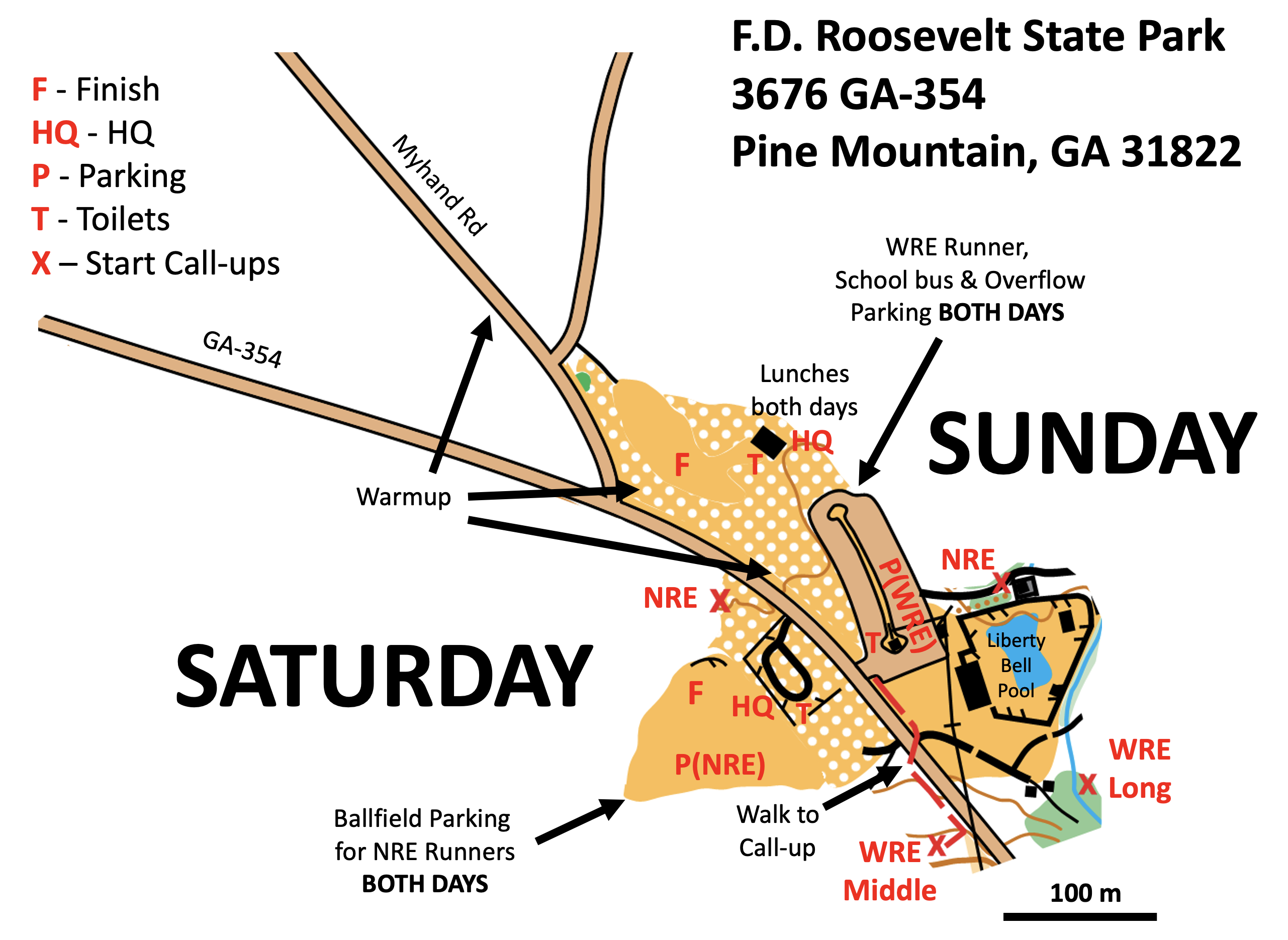
Click map to open PDF in a new window
Location
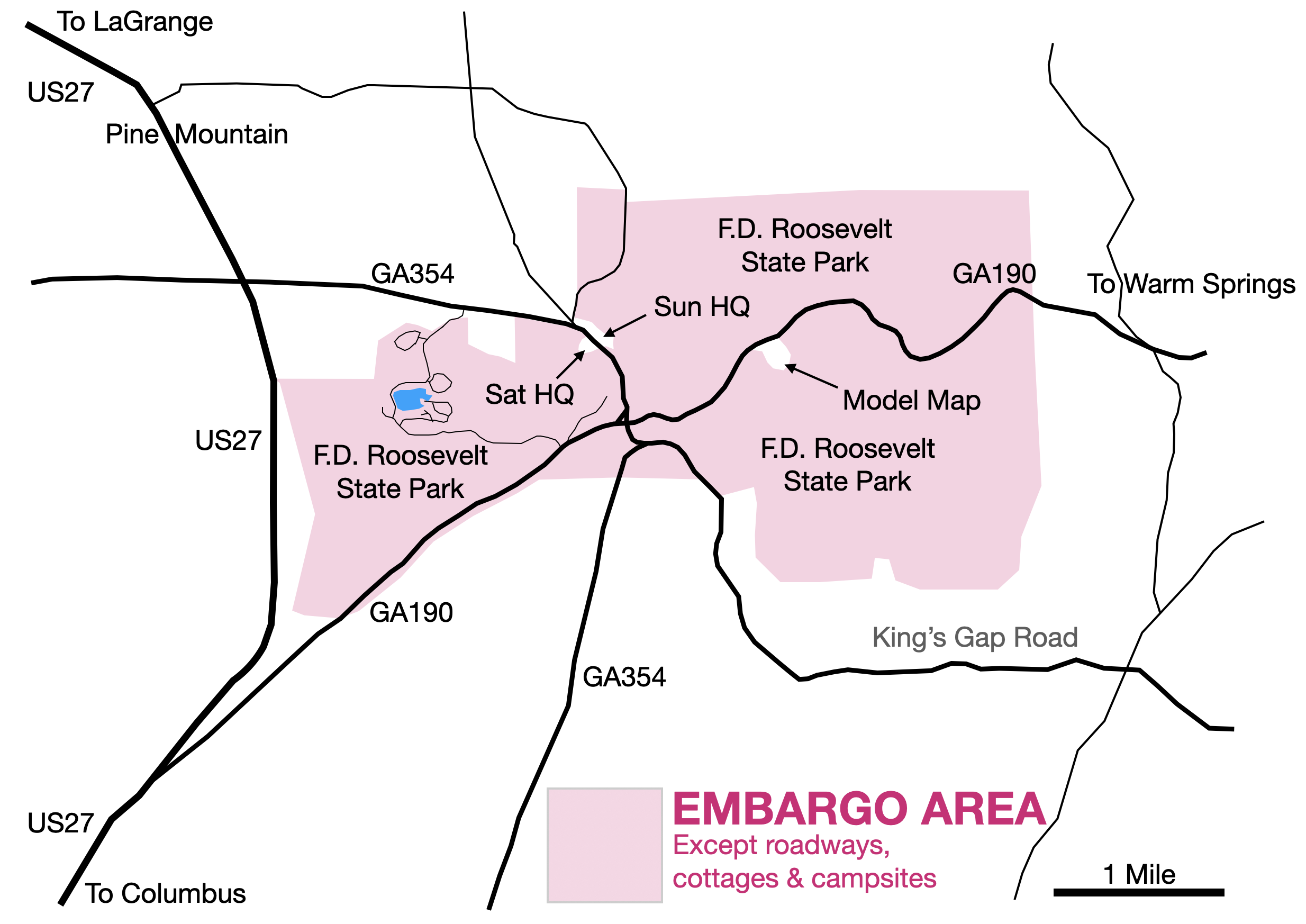
Click map to open PDF in a new window
Meet HQ will be located near the Liberty Bell Pool: 3676 GA-354, Pine Mountain, GA 31822
Park office address and phone: 2970 GA-190, Pine Mountain, GA 31822, (678)450-7726
Meet HQ - see Site and Location Maps above
Saturday
Meet HQ is at the edge of the Ballfield NRE parking. Registration/packet pickup and First Aid will be in the larger white tentWRE runners are not permitted to visit the Meet HQ before finishing their race. If they do not pick up their bib on Friday they must make other arrangements
Sunday
Meet HQ is at the Stone Shelter at the end of the WRE/School bus parking lotRegistration & Check in
Friday -- Packet pick up will be available from 1:00 pm - 4:00 pm at Meet HQ, University of West GeorgiaSaturday -- Packet pick up will be available from 8:30 am - 12:30 pm at Meet HQ
Sunday -- Packet pick up will be available from 9:00 am - 12:30 pm at Meet HQ
Maps
New LIDAR-based map is at 1:10,000 scale with 5 meter contours, except M/F-21+ and WRE classes M/W21E Long courses which will be 1:15,000Embargo
F.D. Roosevelt Map is embargoed June 1 2021The F.D. Roosevelt State Park East maps from the November 15, 2020 meet are available here
Yellow Orange Silver Brown Green Red Blue
The F.D. Roosevelt State Park West maps from the February 7, 2021 meet are available here
White Yellow Orange Silver Brown Green Red
Courses
| Course | SEIS Classes | OUSA/WRE Classes | Sat Dist / Climb / Cntrls | Sun Dist / Climb / Cntrls |
|---|---|---|---|---|
| White | ISPF, ISPM | F-10, F-12 M-10, M-12 M/F White, Grp White |
1.8 km / 60 m / 9 | 1.9 km / 35 m / 10 |
| Yellow | ISIF, ISIM | F-14, M-14 F Yellow, M Yellow, Grp Yellow |
2.8 km / 110 m / 12 | 3.6 km / 100 m / 12 |
| Orange | ISJVF, ISJVM | F-16, M-16 F Orange, M Orange |
4.0 km / 130 m / 11 | 4.6 km / 125 m / 13 |
| Brown X | ISVF | F-18 F55+, F60+, F65+ M65+, M70+, M75+ |
4.4 km / 155 m / 10 | 4.7 km / 165 m / 10 |
| Brown Y | F70+, F75+, F80+ F85+, F90+, F Brown M80+, M85+, M90+, M Brown |
4.1 km / 150 m / 11 | 4.2 km / 130 m / 10 | |
| Green X | ISVM | M-18 M50+, M55+, M60+ M Green |
5.6 km / 220 m / 13 | 5.8 km / 210 m / 11 |
| Green Y | F-20, F35+ F40+, F45+, F50+ F Green |
5.2 km / 180 m / 11 | 5.0 km / 150 m / 10 | |
| Red | M-20, F-21+ M35+, M40+, M45+ M Red |
7.0 km / 195 m / 14 | 7.4 km / 260 m / 13 | |
| Blue | M-21+ | 9.7 km / 360 m / 22 | 10.2 km / 390 m / 17 | |
| W21E | W21 | 5.1 km / 200 m / 15 | 11.5 km / 445 m / 17 | |
| M21E | M21 | 5.8 km / 220 m / 18 | 14.4 km / 720 m / 22 |
Restrooms
Two portapotties (one of them ADA-compliant) and a handwash station will be located on each side of GA-354Additional flushing toilets are available at the Stone Picnic Shelter at the Sunday MeetHQ
Cell Phone Service
Cell phone coverage is not OK everywhere for all carriers. It is much better for Verizon than for AT&T, which is better than T-Mobile. Data coverage can be non-existent in low spots which includes much of Sunday's map. See the FCC’s new 4G LTE mobile broadband mapParking
The Liberty Bell Pool parking lot on the northeastern side of GA-354 is reserved on both days for WRE runners, school buses, the lunch crew and critical meet workers.
Handicapped spaces are in this lot as well, requiring the appropriate government-approved hang tag.
This lot may be used for some overflow parking after these critical needs are met.
The Ballfield on the southwest side of GA-354 is primarily for NRE runners on both days. As you approach from Pine Mountain, turn right into and through the small parking lot into the Ballfield.
The entire site is very compact and it is little hardship to walk from the Ballfield to both NRE starts and both finishes.
All passenger vehicles must have a state park parking pass. Rates are charged based on vehicle capacity, not the number of actual passengers.
Cars and vans with 1-12 passenger capacity are $5/day. You will need a pass for each day you are in the park. Georgia Yellow School buses
are state vehicles, are exempt from parking charges and do not require a parking pass. Buses, other school buses and 13+ passenger vehicles MUST
display a Park Pass each day.
If you are bringing a bus, please contact the Meet Director in advance
You risk a ticket without a parking pass!
You can pull an envelope from the green boxes in the parking areas and follow the instructions if you use cash.
You can buy your Daily Park Pass online.
You can print your pass and place it on your dashboard or simply pull an envelope and write your pass number on it before placing it on your dashboard
Practice Course and Map Legend
The Model Event is 2.2km east of the park office on GA-190 and will be open Friday 8 am to Sunday Noon. See the Location Map above. The maps are free to use from a box at the parking lot. Please return usable maps to the box when you leave. It features the full FDR map legend and the course is shown at both 1:10000 and 1:15000 scale. The controls will be placed by Wednesday and the course will be available to those who print their own maps. The scale bar shown is for the 1:10,000 scale. If you print it, remember to turn off "Fit to page"
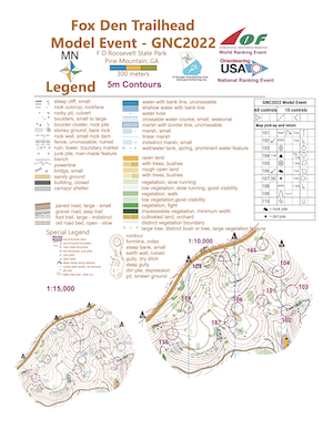
Click map to open PDF in a new window
Babysitting
Babysitting will not be provided. Please do not plan on just leaving your young child at the Meet HQ. Please let the Registrar know if you have special start time requests that would help your own child care arrangements
Emergency Information
In the case of a life-threatening emergency, call 911First aid kits, an AED and first aid assistance will be located at Meet HQ
Should you require additional medical aid, the nearest hospital emergency room is:
Wellstar West Georgia Emergency Department in LaGrange, GA, approximately 22 miles (30 minutes) northwest of F.D. Roosevelt State Park
The contact information is 1514 Vernon Rd, LaGrange, GA 30240 (706)882-1411
Search and Rescue (SAR)
The SAR coordinator is Fred Zendt and his cell phone number is (678) 640-5828. Put this number in your cell phone now
He can be found through Meet HQ. Please coordinate the search and rescue of all missing or injured persons through him
Do not attempt search and rescue operations of your own
Time Limits
Time limit is 2 hours on the WRE Middle courses and 3 hours on all other courses. You must return to the Finish, punch the Finish control and Download your ePunch within the time limit after you start, whether you complete your course or not. Do not go out on a course if you do not have the means to tell the time and how long you have been out. This generally means a watch or a cellphone
Safety
If you have been out for the time limit or it is clear that you cannot finish within the time limit, you must stop and immediately report to the Finish
If unsure, STAY on any road you come across
Carry a whistle. One will be provided upon request. Three (3) short blasts from a whistle indicate an emergency. Blowing the whistle otherwise will result in Disqualification. If you are lost after the courses close, you are already disqualified, and it is an emergency. Please blow your whistle so that we can locate you before it gets dark. You are encouraged to carry a cell phone to be able to call in an emergency. If your calls do not go through, try text messages. Before starting your course, make a contingency plan. Share your start time, expected finish time and contact details with someone who can raise the alarm. The courses close at 4 pm. Sunset is at 5:56 pm and last light is at 6:23 pm
Dress appropriately for the weather conditions!
Assist an injured competitor. If another competitor is hurt and in need of assistance, help to the best of your ability or go to summon help. Report the injured competitor’s bib number and exact location to officials at the Finish or Start line
Warm Up Area
NRE and WRE runners may warm up among the scattered trees and open area on the northeast side of GA-354 as well as along Myhand Rd to the northwest, but are not permitted to enter the woodsNRE runners may also warm up in the Ballfield, paying special attention to parking cars
Clothing Return
No clothing return is provided because of the COVID pandemic. Subject to changeWalk to Start
Saturday
The NRE start is about 100 m north of MeetHQ and the call up can be seen from HQ. From MeetHQ, follow signs and blue flagging tape north to the Call-up
The WRE start is accessed from the Liberty Bell Pool parking lot across GA-354 from the Ballfield.
WRE runners must park in the Liberty Bell Pool parking lot and may not enter the Ballfield or approach the Finish or MeetHQ before they finish.
From the entrance to the parking lot, follow signs and pink flagging tape 150 meters southeast to the call up. Be very careful crossing the road!
Sunday
NRE runners parked in the Ballfield must cross GA-354. Be very careful crossing the road! The NRE start is about 150 meters southeast of MeetHQ. Follow signs and blue flagging tape from the Liberty Bell Pool parking lot to the Call-upThe WRE start is about 250 meters southeast of MeetHQ. Follow signs and pink flagging tape the Liberty Bell Pool parking lot to the Call-up
Control Descriptions
Will be available at the Call-up line and also printed on the mapW21 control descriptions are 142mm x 54mm on Saturday and 148mm x 54mm on Sunday
M21 control descriptions are 148mm x 54mm on Saturday and 178mm x 54mm on Sunday
Call Up
Be at the Call-up area 5 minutes before your Start time. Arrange yourself in start order between the runners who are before and after you. While you are waiting you must wear a mask and social distance at all times. You must wear a mask to approach the Call-up area. Call up is 3 minutes before your start time. There will be three one-minute stages at the Call-up, Mid and Map lines. At the Map line you will receive your map. Your bib number will be written on the back of the map. You must punch at the Mid line and you may remove your mask. If you finish before the last start, we will collect your map at the finish. You may retrieve your map once all competitors have started. There are only sufficient maps for each person to have one each day, so please do not take anyone else’s
Finish Line
When arriving at the finish line, be sure you punch the “Finish” control at the Finish banner. You must put on your mask before approaching the Download Station.
Proceed immediately to the Download Station to have your Ecard read. Take the printout of your results and split times.
If not all competitors have started, you will be asked to turn in your map and pick it up later. Once you have finished, you may not re-enter the competition area without permission of the Meet Director
Rental Ecards must be turned in on the last day of your competition at the Download Station
Course Notes - Andi Berger
Saturday
The NRE start is a little over 100 meters northwest of Saturday HQ and the call up can be seen from HQ. From Saturday HQ, follow signs and blue flagging tape northwest to the call up
The WRE start is accessed from the Liberty Bell Pool parking lot across GA-354 from the Ballfield. WRE runners may not enter the Ballfield or approach the Saturday HQ before their course.
From the entrance to the parking lot, follow signs and pink flagging tape 150 meters southeast to the call up
Advanced courses cross a road used by campers and other park visitors. Although most drivers drive slowly on this road, please use caution when crossing
Safety bearing: Go east to find a road, then navigate to the finish
Sunday
The NRE start is about 150 meters southeast of Sunday HQ. From Sunday HQ, follow signs and blue flagging tape southeast to the call upThe WRE start is about 250 meters southeast of Sunday HQ. Follow signs and pink flagging tape southeast to the call up
A few controls and legs on the Blue and M21E courses are near the park boundary. The park boundary is drawn as a dashed purple line on the map and marked in the woods with yellow painted stripes on trees. Do not cross the park boundary
The White and Yellow courses have a few flagged legs. Flagged legs on the White course will use white tape while flagged legs on the Yellow course will use yellow tape
The last few legs of all courses are near the park’s “Pioneer” camping area. This is a primitive camping area with 4 group campsites. Three of the 4 campsites are reserved by groups not associated with our event. These 3 campsites are mapped as out-of- bounds. Do not run through these 3 campsites so that any campers there are not disturbed. We have reserved one campsite, which is not marked out-of-bounds on the map. The campsite we have reserved (not mapped as out-of-bounds) is okay to run through
Safety bearing: White, Yellow, Orange, Brown Y, Green Y courses - Go west to find a paved road, then navigate to the finish. Be careful of traffic
Safety bearing: Brown X, Green X, Red, Blue, W21E, M21E courses - Go west or south to the nearest paved road, then navigate to the finish. Be careful of traffic
Map Notes - Bill Cheatum
The FD Roosevelt State Park map of Pine Mountain is an updated version of the map used for the 2017 Georgia Navigator Cup. The map will be rendered at 1:10,000 and 1:15,000 scales, as appropriate to age class, with a 5m contour interval. The forests of Pine Mountain are generally open and runnable. The following symbols are defined on each map. A complete map legend can be found on the Model Event mapsMany rootstocks, the most prominent and temporary point features on the map, have been eliminated as they have deteriorated to less than 1 meter in height. However, many 1m+ have remained, and are depicted with a green "X"
The vertical green lines depict fallen tree tops that are dense enough to require a detour. There are many fallen trees that are not mapped but don't present a significant navigation obstacle
The irregular triangle (boulder field) is used to depict a rock pile, most often manmade and common on piedmont forests
The brown dot (knoll) is a distinct dirt pile, also manmade but often a remnant of a large rootstock
A black "X" denotes a standing man made structure (signs, benches) and a black "o" are low structures or junk piles
The ruined earth wall symbol is used here to depict the terraces formed when earth walls were constructed to stop erosion in cotton fields. They often run parallel to contours, but not always, and several may occur within one 5m contour interval
Many streams at the base of the mountain have eroded steep banks and are difficult to cross. These sections have been marked with the earth bank symbol (without tags)
Many of these features can be seen at the Model Event, 2.2km east of the park office on GA-190. The Model Event will be open Friday Noon to Sunday Noon. The maps are free to use from a box at the parking lot. Please return usable maps to the box when you leave