
Sat Jan 18 & Sun Jan 19 -- Camp Rutledge, Hard Labor Creek State Park
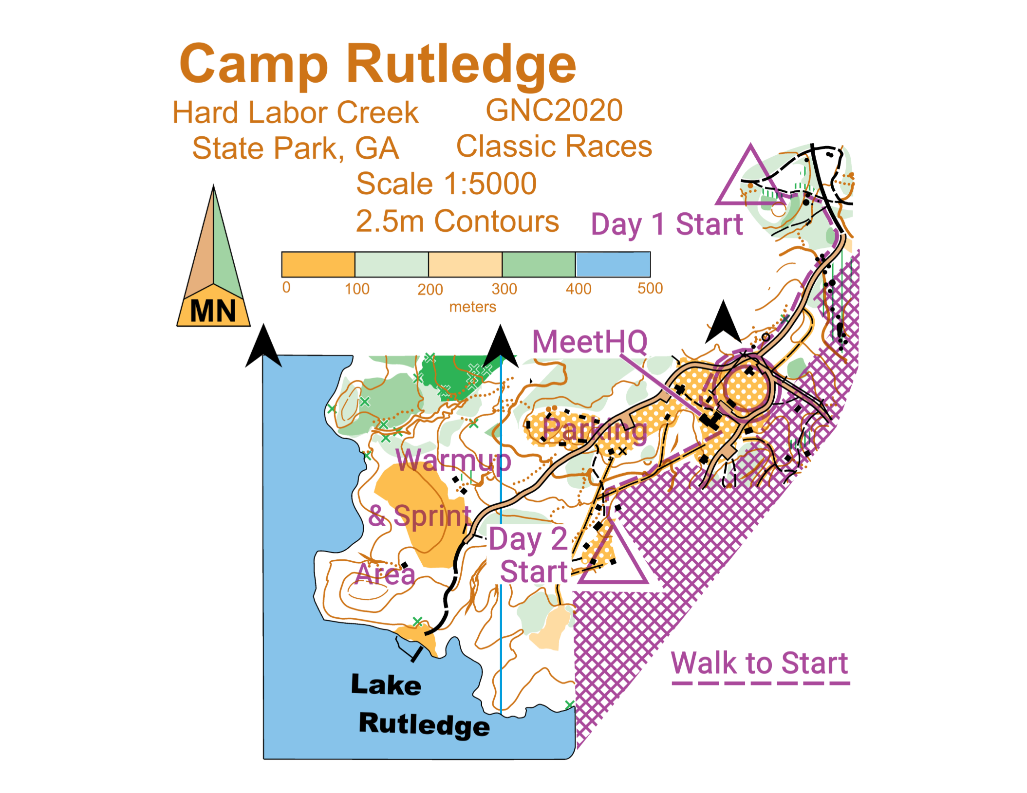
Site Map
Location
Park office address and phone: 5 Hard Labor Creek Road, Rutledge, GA 30663, (706) 557-3001Access to Camp Rutledge is from the intersection of Fairplay Rd and Camp Rutledge Rd
Meet HQ
Meet HQ is in the Dining Hall at Camp RutledgeRegistration & Check in
Friday -- Packet pick up will be available from 7:30 pm - 8:00 pm at:Hampton Inn Covington, 14460 Paras Drive (formerly Lochridge Blvd), Covington, GA 30014, (678) 212-2500
Saturday -- Packet pick up will be available from 9:00 am - 11:00 am at Meet HQ
Sunday -- Packet pick up will be available from 8:00 am - 10:00 am at Meet HQ
Maps
Map is at 1:10,000 scale with 2.5 meter contours, except F-21+ and M-21+ which will be 1:15,000Embargo
Camp Rutledge Map is embargoed Jun 1, 2019Lake Rutledge Beach Map is embargoed Jun 1, 2019 (Blue and Red courses only)
Courses
| Course | SEIS Classes | OUSA Classes | Sat dist km / climb m | Sun dist km / climb m |
|---|---|---|---|---|
| White | ISPF, ISPM | F-10, F-12 M-10, M-12 M/F White, Grp White | 2.8 km / 55 m | 3.1 km / 75 m |
| Yellow | ISIF, ISIM | F-14, M-14 F Yellow, M Yellow, Grp Yellow | 3.7 km / 100 m | 2.6 km / 70 m |
| Orange X | ISJVM | M-16 | 4.1 km / 105 m | 4.5 km / 80 m |
| Orange Y | ISJVF | F-16 F Orange, M Orange, Grp Orange | 4.0 km / 110 m | 4.5 km / 80 m |
| Brown X | ISVF | F-18 F55+, F60+, F65+ M65+, M70+, M75+ | 4.1 km / 115 m | 4.4 km / 100 m |
| Brown Y | F70+, F75+, F80+ F85+, F90+ M80+, M85+, M90+ F Brown, M Brown | 3.1 km / 90 m | 3.2 km / 85 m | |
| Green X | ISVM | M-18 M50+, M55+, M60+ M Green | 5.9 km / 160 m | 5.3 km / 130 m |
| Green Y | F-20, F35+ F40+, F45+, F50+ F Green | 5.2 km / 160 m | 5.2 km / 130 m | |
| Red | F-21+, M-20 M35+, M40+, M45+ M Red | 7.5 km / 235 m | 7.2 km / 170 m | |
| Blue | M-21+ | 9.8 km / 335 m | 10.1 km / 225 m |
Restrooms
All the toilet/shower blocks will be in service at Camp Rutledge this weekend! Hot showers will be available throughout the duration of the meet, including after the Extreme-O. The Central Shower House opposite the Meet HQ will be open at all times. There are 4 Camp Units in the park, each one with a Shower House. On Saturday, only the Unit 1 Shower House will also be available and will be signposted. It is in the Warm Up area, across the road from Unit 1, which is north of the road. On Sunday, the Unit 2 Shower House, which is at the Day 2 Start, will also be available. Units 3 and 4 are out of bounds until after the Sunday races
The camp is vintage, and the plumbing can be finicky. If a toilet gets blocked, please report it immediately to meet personnelCell Phone Service
Cell phone coverage is generally good for all carriers. AT&T has coverage throughout the park but 4G coverage generally does not extend down to the lakeParking
All passenger vehicles must have a state park parking pass. Rates are charged based on vehicle capacity, not the number of actual passengers. Cars and vans with 1-12 passenger capacity are $5/day. Passes will be available at the Middle and at packet pickup on Friday. Passes MAY be available at MeetHQ on Saturday. You will need a pass for each day you are in the park
If you arrive at the park without a parking pass - you did not purchase one at the Middle or at the packet pickup - then you should buy at least one before driving to the Meet HQ. Camp Rutledge Road is a long, narrow gravel road and you will not enjoy driving against traffic to get a parking pass. You may purchase one with exact change from the green boxes at the Park Office. You may also purchase one from the Park Office, or from the guard shack at the park entrance by the Park Office, if it is staffed. They would be able to make change
Georgia Yellow School buses are state vehicles, are exempt from parking charges and do not require a parking pass. Buses, other school buses and 13+ passenger vehicles MUST stop by the Park Office to pick up their Park Passes for the weekend. Office hours are 8:00am to 5:00pm. If you are bringing a bus, please contact the Meet Director in advanceYou risk a ticket without a parking pass!
Practice Course
A practice course is located on the Lake Brantley Map adjacent to the Park Office. Start and finish will be at the trailhead across from the Park Office. Bagged and sealed maps will be available at the trail head and should be returned after use. The practice course opens 3 pm Friday Jan 17 and closes noon Sunday Jan 19. The Practice course may only be used during daylight hours. A parking pass is required
The Practice course map is also available here
Jan 18 and 19 -- Recreational Map Hikes
A limited number of non-competitive Orienteering spaces are available on a beginner's level course. Beginner instruction is availableThe Map Hike is NOT the same as any competitive course. Register at the Meet HQ. Map Hike will use manual punching. $10 per map, $3 per extra map
Saturday 10:00 am – 1:00 pm, must return by 3pm
Sunday 10:30 am - noon, must return by 2pm
Free Sprint Courses in Warm Up Area
Three Sprint courses in the Warm Up Area are available to registered GNC and Map Hike participantsThe controls are programmed in beacon mode so that runners can test their SIAC skills. An SI Printer is available to print splits. Check in at the Map Hike table for details and to participate
Babysitting
Babysitting will not be provided. Please do not plan on just leaving your young child at the Meet HQ. Please let the Registrar know if you have special start time requests that would help your own child care arrangements
Emergency Information
In the case of a life-threatening emergency, call 911.First aid kits, an AED and first aid assistance will be located at Meet HQ.
Should you require additional medical aid, the nearest hospital emergency room is:
Piedmont Newton Hospital in Covington, GA, approximately 18 miles to the west of Hard Labor Creek State Park along I-20 towards Atlanta. The contact information is Newton Medical Ctr 5126 Hospital Dr NE, Covington, GA 30014-2566 (770) 786-7053
Search and Rescue (SAR)
The SAR coordinator is Bill Cheatum and his cell phone number is (706)247-5031. Put this number in your cell phone now
He can be found through Meet HQ. Please coordinate the search and rescue of all missing or injured persons through him
Do not attempt search and rescue operations of your own
Time Limits
Time limit is 3 hours on all courses. You must return to the Finish, punch the Finish control and Download your ePunch within 3 hours after you start, whether you complete your course or not. Do not go out on a course if you do not have the means to tell the time and how long you have been out. This generally means a watch or a cellphone
Safety
A Preview Map for Saturday and Sunday (at the scale of 1:6500) will be available at the start line with safety/emergency instructions
If you have been out for 3 hours or it is clear that you cannot finish in 3 hours, you must stop and immediately report to the Finish. The safety bearing is west (270 degrees). If lost, follow the emergency bearing to a trail or road and re-locate. If unsure, STAY on any road you come across
Carry a whistle. One will be provided upon request. Three (3) short blasts from a whistle indicate an emergency. Blowing the whistle otherwise will result in Disqualification. If you are lost after the courses close, you are already disqualified, and it is an emergency. Please blow your whistle so that we can locate you before it gets dark. You are encouraged to carry a cell phone to be able to call in an emergency. If your calls do not go through, try text messages. Before starting your course, make a contingency plan. Share your start time, expected finish time and contact details with someone who can raise the alarm. The courses close at 4 pm on Saturday and 3 pm on Sunday. Sunset is at 5:55 pm and last light is at 6:15 pm
Dress appropriately for the weather conditions. Although conditions in Georgia are often mild in January, you should be prepared for chilly and wet conditions. If the ground is wet, exposed red clay will be extremely slippery. Please be careful not to slip on it
Some gullies are extremely deep with very steep sides. If the ground is wet, the sides will be very slippery. Cross them with extreme care. Make sure you can see a way out before you get in one
There are several active horse trails on the map. There is a good chance you will use or cross horse trails and possibly see horses while on your course. If you meet horses on the trail, please give them a wide berth. If you can't leave the trail and give them at least 20 or 30 meters clearance, slow down or stop if the horse seems skittish. Talking to the rider in conversational tones also helps calm the horse
Assist an injured competitor. If another competitor is hurt and in need of assistance, help to the best of your ability or go to summon help. Report the injured competitor’s bib number and exact location to officials at the Finish or Start line
The SAR coordinator is Bill Cheatum and his cell phone number is (706)247-5031. Put this number in your cell phone now
Warm Up Area
A small warm up area is located near the Meet HQ. See the Warm Up map hereClothing Return
Clothing will be returned from the start line to Meet HQ regularly. Please ensure that you can identify your warm-ups and pick them up promptly after your run. Unclaimed warmups will be donated to the needyWalk to Start
Routes are marked with blue flagging tapeSaturday walk is 470 m from Meet HQ
Sunday walk is 300 m from Meet HQ
Control Descriptions
Will be available at the middle start line and are also printed on the mapCall Up
Be at the Call-up line at least 5 minutes before your Start time. Call-up is 3 minutes before your start time. There will be three one-minute stages at the Call-up, Middle and Map lines. Control descriptions are available at the middle line. At the Map line you will receive your map. Write your bib number on the back of the map with the marker provided. If you finish before the last start, we will collect your map at the finish. You may retrieve your map once all competitors have started. There are only sufficient maps for each person to have one each day, so please do not take anyone else’s
Finish Line
When arriving at the finish line, be sure you punch the “Finish” control at the Finish banner. If all competitors have not started, you will be asked to turn in your map and pick it up later. Proceed immediately to the Download Station to have your Ecard read. You will receive a printout of your results and split times. Once you have finished, you may not re-enter the competition area without permission of the Meet Director. Rental ePunch must be turned in on the last day of your competition at the Download Station
Map Notes
The Hard Labor Creek State Park maps have ~2.5m contours produced from LIDAR digital data, and point and linear features optimized for the commonly used scale of 1:10000. Standard IOF map symbols are used with these exceptions:
The minimum size of point features is ~.5 meter. An exception is a ~1 meter minimum for Rootstocks (root ball of fallen trees) and is now a green “X” symbol. Stumps are not mapped.
The small right triangle depicts rock piles. This symbol is normally used to show “boulder fields”, a feature seldom seen in the South.
The minimum size rock wall symbol indicates a small rock dam, usually located in an erosion ditch, gully or reentrant. This feature may be less than .5 meters tall but is an important cultural aspect of the terrain.
Logs that can be used to safely cross streams, are shown as a short, dark green line. Use care in crossing streams on logs or rocks, as they are slippery.
Land form features:
Extensive use of the “dry ditch” symbol to depict small, narrow and easily crossed erosion ditches and their linear extent in the terrain. They are a distinct feature in the landscape and are not always associated with a reentrant. These are often used as control points on the GNC2020 courses.
The “gully” symbol (thick brown line, pointed at both ends) indicate a narrow gully deeper than 1 meter and more difficult to cross than a ditch. This, too, will be a common control point.
Streams and reentrants with steep sides, that are very difficult to cross, are indicated with thicker brown lines. These lines indicate the shape and extent of very deep gullies or stream bed edges. Very steep and high earth banks are marked as black cliff symbols to indicate they are dangerous and to be avoided.
Light green indicates slight resistance to running from many small understory trees but the visibility is usually good.
Medium green indicates more resistance to running, generally from a mix of young pine trees and small trees, as in light green. The visibility is significantly reduced.
Dark green is a fight to transit. It is a mix of dense planted pines and briers. Don’t go there.
Welcome to the forests of Hard Labor Creek State Park and to the old CCC camp at Rutledge.
Bill CheatumCourse Notes
Saturday
Saturday's walk to the start is 470 meters from Meet HQ and is flagged with blue tape
Point features (boulders, rock dams, rock piles, knolls, etc.) as small as one half meter may be used for control locations; all point feature control descriptions include the height of the feature. Rock piles are mapped as boulder fields (small right triangle) and are described as boulder clusters (double triangle) in the control descriptions
The White course and Yellow course have two flagged legs each. Flagged White course legs use white tape, and flagged Yellow course legs use yellow tape
Route choices on the Intermediate through Advanced courses include areas with many small trees that will slightly slow down your run, mapped as light green
All courses have at least one creek crossing where you will probably get your shoes wet. Rocks and boulders in the creeks are very slippery, especially when wet, so be careful when crossing
Some controls are placed very close to the park boundary where a trail runs almost parallel to a barbed wire fence that is flagged with pink surveyor's tape or yellow Caution tape. You should not have to cross a barbed wire fence. If you are on White or Yellow, you should not even have to cross this trail. If you come to a barbed wire fence that is flagged with pink surveyor's tape or yellow Caution tape, do not cross it unless you know you are outside the park. The edge of the park is marked by a dashed purple line
Safety Bearing: Head west until you reach the lake, then navigate to the finish
Andi Berger, Saturday Course Setter/Sunday VetterSunday
There is a 300 meter walk to the start on Sunday
Red and Blue courses will cross Hard Labor Creek on a gravel road bridge. There will be a control at the crossing, which you will punch twice, once on the way out, and once on the way back This is indicated in the control descriptions
Safety Bearing: Head west until you reach the lake, then navigate to the finish. If you are on Red or Blue and have already crossed the bridge once, then the safety bearing is east until you hit the lake or river, navigate to bridge
Sam Smith, Sunday Course Setter/Saturday Vetter