
Friday Apr 9 -- McIntosh Reserve Park
GAOC is implementing special COVID rules for event participants to maintain the health and safety of all participants and volunteers and to comply with state and local laws and park regulations. By entering in and attending the event you are agreeing to abide by these rules. Please make sure you read and understand them
In particular, please read, understand and comply with the rules on Masks, Social Distancing, Start, Finish and Results. There will be NO water on the course. Participants are strongly encouraged to carry water according to their needs
Participants should NOT attend if they feel unwell, have a fever, have recently been exposed to COVID-19 or should be in quarantine for any reason
Site Map
Location
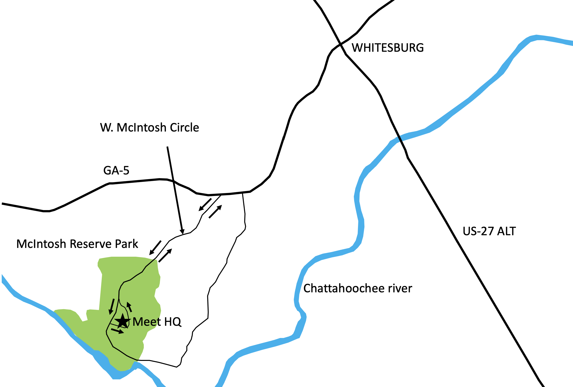
Address: 1046 W McIntosh Cir, Whitesburg, GA 30185, (770) 830-5879
McIntosh Reserve Park website
*** Please obey the speed limits within the park at all times ***
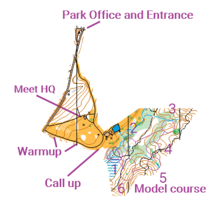
Meet HQ
Meet HQ is at Shelter 2, McIntosh Reserve.Registration & Check in
Packet pick up will be available at Meet HQ from 12:30 pm - 4:00 pmStarts
Starts will be from 2:15 pm - 4:30 pm. Maximum Time is 2 hours. Courses close 6:30 pmMaps
Map is 1:10,000 scale with 2.5 meter contours, ISOM2017-2 standardEmbargo
Park is embargoed December 21, 2020 (4 month requirement waived by OUSA Sanctioning Committee)The McIntosh Reserve Red course map from the December 20, 2020 meet will be available on-site
All the course maps are here White Yellow Orange Brown Green Red
Courses
| Course | OUSA Classes | Dist/Climb/Cntrls |
|---|---|---|
| White | F-10, F-12 M-10, M-12 M/F White, Grp White | 2.5 km / 30 m / 13 |
| Yellow | F-14, M-14 F Yellow, M Yellow, Grp Yellow | 2.5 km / 45 m / 10 |
| Orange | F-16, M-16 F Orange, M Orange | 3.1 km / 70 m / 13 |
| Brown | F-18 F55+, F60+, F65+ F70+, F75+, F80+ F85+, F90+ M65+, M70+, M75+ M80+, M85+, M90+ F Brown, M Brown | 3.4 km / 65 m / 11 |
| Green | M-18, F-20, F35+ F40+, F45+, F50+ M50+, M55+, M60+ F Green, M Green | 3.7 km / 85 m / 13 |
| Red | F-21+, M-20 M35+, M40+, M45+ M Red | 4.3 km / 95 m / 14 |
| Blue | M-21+ | 4.9 km / 105 m / 16 |
Restrooms
Restrooms are available at the park near the Meet HQCell Phone Service
Cell phone coverage is generally poor for all carriers and very poor for ATT. If a phone call won't go through, try sending a textParking
Parking is plentiful at Meet HQ. There is a $5 park entry feePractice map
A small practice area is located south of the toilet block near Meet HQ. Model course will be open 1:00 pm-4:00 pmPractice maps are available at Registration. Practice start/finish is at the trail junction. See the Practice Map for details
Practice map is also available here
Babysitting
Babysitting will not be provided. Please do not plan on just leaving your young child at the Meet HQ. Please let the Registrar know if you have special start time requests that would help your own child care arrangements
Emergency Information
In the case of a life-threatening emergency, call 911First aid kits and an AED will be located at Meet HQ
Should you require additional medical aid, the nearest hospital emergency rooms are:
Tanner Medical Center/Carrollton in Carrollton, GA, approximately 17 miles NW of McIntosh Reserve
The contact information is Tanner Medical Center/Carrollton, 705 Dixie St, Carrollton, GA 30117, (770) 836-9666
18 reviews/2.1* on Google
Piedmont Newnan Hospital in Newnan, GA, approximately 18 miles SE of McIntosh Reserve
The contact information is Piedmont Newnan Hospital, 745 Poplar Rd, Newnan, GA 30265, (770) 400-1000
11 reviews/2.9* on Google
Search and Rescue (SAR)
The SAR coordinator is Andi Berger and her cell phone number is (770)314-5460. Put this number in your cell phone now
She can be found through Meet HQ. Please coordinate the search and rescue of all missing or injured persons through her
Do not attempt search and rescue operations of your own
Time Limits
Time limit is 2 hours on all courses. You must return to the Finish, punch the Finish control and Download your ePunch within 2 hours after you start, whether you complete your course or not. Do not go out on a course if you do not have the means to tell the time and how long you have been out. This generally means a watch or a cellphone
Safety
If you have been out for 2 hours or it is clear that you cannot finish in 2 hours, you must stop and immediately report to the Finish. A paved road runs more or less from North to South through the center of the map. Keep track of which side of this road you are on. If you are on the East side of the road, head West to the road, relocate and navigate along the road to the finish area. If you are on the West side of the road, head East to the road, relocate and navigate along the road to the finish area. If unsure, STAY on any road you come across
Carry a whistle. One will be provided upon request. Three (3) short blasts from a whistle indicate an emergency. Blowing the whistle otherwise will result in Disqualification. If you are lost after the courses close, you are already disqualified, and it is an emergency. Please blow your whistle so that we can locate you before it gets dark. You are encouraged to carry a cell phone to be able to call in an emergency. If your calls do not go through, try text messages. Before starting your course, make a contingency plan. Share your start time, expected finish time and contact details with someone who can raise the alarm. The courses close at 6:30 pm. Sunset is at 8:06 pm and last light is at 8:32 pm
Dress appropriately for the weather conditions. Although conditions in Georgia are often warm in April, you should be prepared for sudden thunderstorms. If the ground is wet, exposed red clay will be extremely slippery. Please be careful not to slip on it
Assist an injured competitor. If another competitor is hurt and in need of assistance, help to the best of your ability or go to summon help. Report the injured competitor’s bib number and exact location to officials at the Finish or Start line
The SAR coordinator is Andi Berger and her cell phone number is (770)314-5460. Put this number in your cell phone now
There are several active horse trails on the map. There is a good chance you will use or cross horse trails and possibly see horses while on your course. If you’re on a trail and meet or need to pass a horse and rider, slow down and get off the trail. Make sure not to make abrupt movements and talk calmly when approaching to avoid startling the animal. Give the horse and rider as wide a berth as possible, on the downhill side. Horses are more likely to run uphill than downhill when spooked, and you definitely don’t want to be in the path of a spooked horse
what3words - foolishly.nonexistent.progress
When you have cell phone service, you can use the what3words app and Google Maps to navigate to the finish in the event of an emergency.
Enter the 3 words foolishly.nonexistent.progress into the what3words app to locate the finish.
Click on Navigate and use the Google Maps app to navigate to the finish. Install the what3words app on your cell phone now and try it out
Clothing Return
No clothing return is provided due to the COVID pandemic. However, the start is close to parking and Meet HQWarm up
Warm up will be along the side of the single lane paved road on the southern edge of the finish field. All areas to each side are out of boundsWalk to Start
The Call-up area for the start will be clearly visible on the south side of the single lane paved road on the southern edge of the finish fieldControl Descriptions
Will be available at packet pickup and also printed on the map. Control descriptions will NOT be available at the StartThey are also available for downloading and printing here
Call Up
You must wear a mask to approach the Call-up. Be at the Call-up 5 minutes before your Start time. Call up is 2 minutes before your start time. There will be two one-minute stages at the Call-up and Map lines. Control descriptions will NOT be available, except on your map. At the Map line you will receive your map. Your bib number will be written on the back of the map. You may remove your mask immediately before punching Start. If you finish before the last start, we will collect your map at the finish. You may retrieve your map once all competitors have started. There are only sufficient maps for each person to have one each day, so please do not take anyone else’s
Finish Line
When arriving at the finish line, be sure you punch the “Finish” control at the Finish banner. You must put on your mask before approaching the Download Station. Proceed immediately to the Download Station to have your Ecard read. Take the printout of your results and split times. If not all competitors have started, you will be asked to turn in your map and pick it up later. Once you have finished, you may not re-enter the competition area without permission of the Meet Director
Course Setter Notes
McIntosh Reserve is a 527-acre park that is adjacent to the Chattahoochee river and is the former plantation of Chief William McIntosh. The woods are relatively open and runnable although it can be thick in a few areas so watching the map is a good idea. Most courses will have some open fields to cross during the race for a change of terrain. The park has less elevation changes than Don Carter State Park, but the 2.5 meter contours do show a variety of reentrants throughout the park. Some complex gully and stream systems will make some legs and controls interesting. Picnic tables in the area of the race are mostly unmapped. There is a maintenance shed area surrounded by barbed wire in the middle of map that is out of bounds.
Map Notes
McIntosh Reserve, bordering the north side of the Chattahoochee River, is mostly ridge and reentrant terrain,
with a few large flat fields thrown in. The map uses symbols set forth in ISOM 2017. Scale for all Middle
courses is 1:10,000, with 2.5m contours. North lines are spaced at 300m.
Rootstocks are mapped with the green X symbol. Rectangular concrete picnic tables are mapped with the black O
symbol. Other picnic tables are too small to be mapped. Other man-made objects are mapped with the black X symbol.
Large trees are mapped with the green O symbol, and medium sized trees with the green filled circle symbol.
A park maintenance area is mapped as an olive green "Area that shall not be entered". The maintenance area is
largely surrounded by a poorly maintained barbed wire fence. The interior of this area is marked on the map with
purple crosshatch. Crossing this area is forbidden.
Be mindful of the park boundaries. The area outside the map is private property. There are numerous private property signs,
but not enough that it's impossible to mistakenly cross the park boundary. Stay on the map!