
Sat Apr 10 & Sun Apr 11 -- Don Carter State Park
GAOC is implementing special COVID rules for event participants to maintain the health and safety of all participants and volunteers and to comply with state and local laws and park regulations. By entering in and attending the event you are agreeing to abide by these rules. Please make sure you read and understand them
In particular, please read, understand and comply with the rules on Masks, Social Distancing, Start, Finish and Results. There will be NO water on the course. Participants are strongly encouraged to carry water according to their needs
Participants should NOT attend if they feel unwell, have a fever, have recently been exposed to COVID-19 or should be in quarantine for any reason
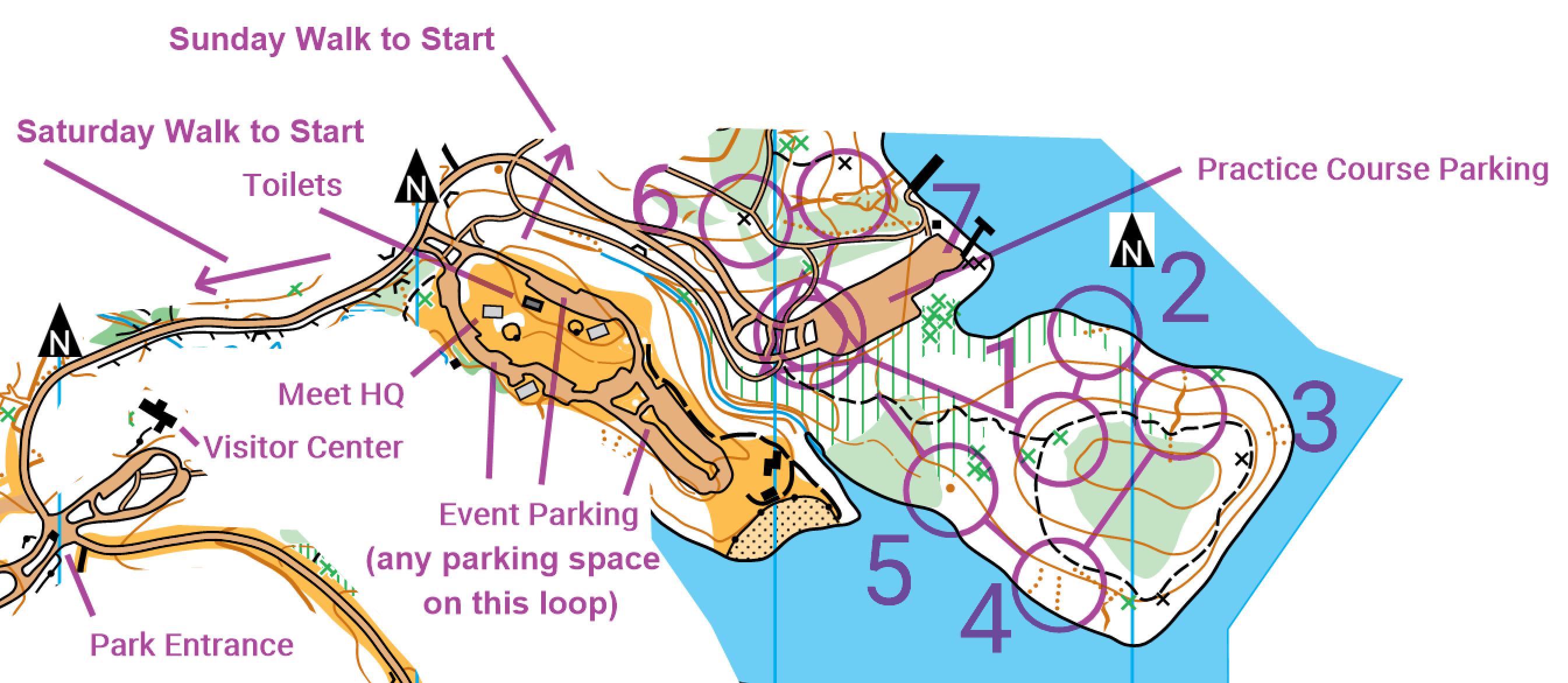
Site Map
Location
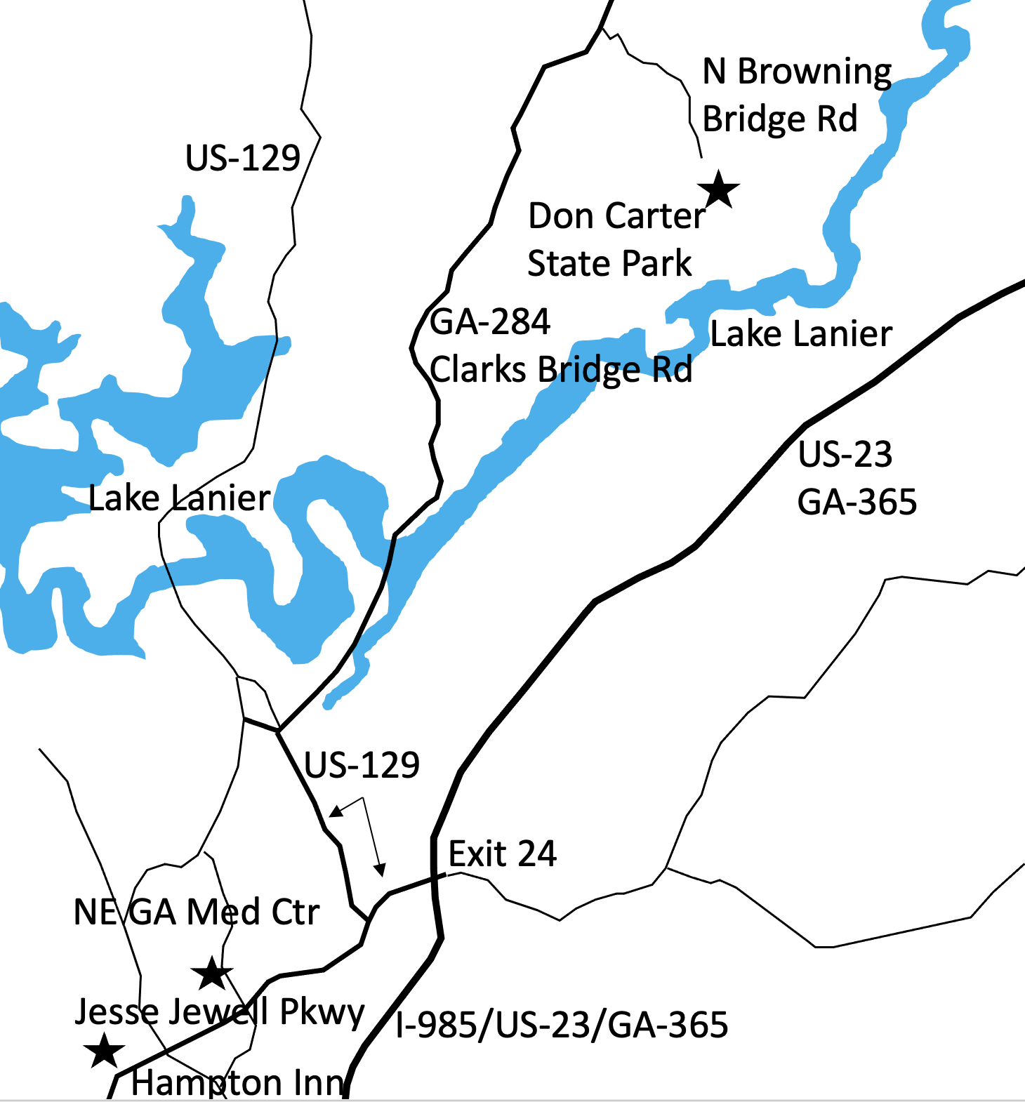
Park office address and phone: 5000 N Browning Bridge Rd, Gainesville, GA 30506, (678)450-7726
Meet HQ
Meet HQ is Shelter #1 at Don Carter State ParkRegistration & Check in
Friday -- Packet pick up will be available from 12:30 pm - 4:00 pm at Meet HQ, McIntosh ReserveSaturday -- Packet pick up will be available from 8:30 am - 12:45 pm at Meet HQ
Sunday -- Packet pick up will be available from 8:30 am - 12:45 pm at Meet HQ
Maps
Map is at 1:10,000 scale with 5 meter contours, except M-21+ which will be 1:15,000Embargo
Don Carter Map is embargoed December 14, 2020 (4 month requirement waived by OUSA Sanctioning Committee)The Don Carter State Park Red map from the December 13, 2020 meet will be available on-site
All the course maps are here White Yellow Orange Silver Brown Green Red
Courses
| Course | SEIS Classes | OUSA Classes | Sat Dist / Climb / Cntrls | Sun Dist / Climb / Cntrls |
|---|---|---|---|---|
| White | ISPF, ISPM | F-10, F-12 M-10, M-12 M/F White, Grp White | 2.9 km / 100 m / 11 | 2.4 km / 85 m / 13 |
| Yellow | ISIF, ISIM | F-14, M-14 F Yellow, M Yellow, Grp Yellow | 3.0 km /115 m / 12 | 2.6 km / 80 m / 14 |
| Orange | ISJVF, ISJVM | F-16, M-16 F Orange, M Orange | 4.2 km / 155 m / 16 | 4.3 km / 170 m / 16 |
| Brown X | ISVF | F-18 F55+, F60+, F65+ M65+, M70+, M75+ | 4.1 km / 140 m 15 | 4.5 km / 180 m / 12 |
| Brown Y | F70+, F75+, F80+ F85+, F90+ M80+, M85+, M90+ F Brown, M Brown | 3.5 km / 110 m / 13 | 3.1 km / 135 m / 10 | |
| Green X | ISVM | M-18 M50+, M55+, M60+ M Green | 6.0 km / 225 m / 16 | 6.4 km / 255 m / 17 |
| Green Y | F-20, F35+ F40+, F45+, F50+ F Green | 5.1 km / 195 m / 15 | 5.1 km / 220 m / 13 | |
| Red | M-20, F-21+ M35+, M40+, M45+ M Red | 8.0 km / 300 m / 25 | 8.7 km / 375 m / 20 | |
| Blue | M-21+ | 10.3 km / 420 m / 31 | 10.0 km / 405 m / 26 |
Restrooms
There is a large restroom block near Meet HQ. There will be a portable toilet near the starts on Saturday and two portable toilets near the starts on Sunday
Cell Phone Service
Cell phone coverage is generally good for all carriersParking
All passenger vehicles must have a state park parking pass. Rates are charged based on vehicle capacity, not the number of actual passengers. Cars and vans with 1-12 passenger capacity are $5/day. You will need a pass for each day you are in the park
Georgia Yellow School buses are state vehicles, are exempt from parking charges and do not require a parking pass. Buses, other school buses and 13+ passenger vehicles MUST stop by the Park Office to pick up their Park Passes for the weekend. Office hours are 8:00am to 5:00pm. If you are bringing a bus, please contact the Meet Director in advanceYou risk a ticket without a parking pass!
Practice Course
A small practice area is located around the North Boat Ramp parking lot near Meet HQ. Model course will be open from noon on Friday until noon on SundayPractice maps are available at Registration. See the Practice Map for details
Practice map is also available here
Babysitting
Babysitting will not be provided. Please do not plan on just leaving your young child at the Meet HQ Please let the Registrar know if you have special start time requests that would help your own child care arrangements
Emergency Information
In the case of a life-threatening emergency, call 911First aid kits, an AED and first aid assistance will be located at Meet HQ
Should you require additional medical aid, the nearest hospital emergency room is:
Northeast Georgia Medical Center in Gainesville, GA, approximately 11 miles southwest of Don Carter State Park. The contact information is Northeast Georgia Medical Center 743 Spring St SE, Gainesville, GA 30501 (770) 219-1200
Search and Rescue (SAR)
The SAR coordinator is Fred Zendt and his cell phone number is (678) 640-5828. Put this number in your cell phone now
He can be found through Meet HQ. Please coordinate the search and rescue of all missing or injured persons through him
Do not attempt search and rescue operations of your own
Time Limits
Time limit is 3 hours on all courses. You must return to the Finish, punch the Finish control and Download your ePunch within 3 hours after you start, whether you complete your course or not. Do not go out on a course if you do not have the means to tell the time and how long you have been out. This generally means a watch or a cellphone
Safety
If you have been out for 3 hours or it is clear that you cannot finish in 3 hours, you must stop and immediately report to the Finish.
Saturday Safety Bearing: Go north to find a road, then navigate to finish.
Sunday Safety Bearing: Go south. You should come to either:
- the main park road that you drove in on, go east to the finish
- the lake, follow the lakeshore west to a bridge over Dog Creek. Follow this main trail west to a paved trail. Follow the paved trail southeast to the Start area.
Carry a whistle. One will be provided upon request. Three (3) short blasts from a whistle indicate an emergency. Blowing the whistle otherwise will result in Disqualification. If you are lost after the courses close, you are already disqualified, and it is an emergency. Please blow your whistle so that we can locate you before it gets dark. You are encouraged to carry a cell phone to be able to call in an emergency. If your calls do not go through, try text messages. Before starting your course, make a contingency plan. Share your start time, expected finish time and contact details with someone who can raise the alarm. The courses close at 4 pm. Sunset is at 8:03 pm and last light is at 8:23 pm
Dress appropriately for the weather conditions. Although conditions in Georgia are often warm in April, you should be prepared for sudden thunderstorms. If the ground is wet, exposed red clay will be extremely slippery. Please be careful not to slip on it
Assist an injured competitor. If another competitor is hurt and in need of assistance, help to the best of your ability or go to summon help. Report the injured competitor’s bib number and exact location to officials at the Finish or Start line
The SAR coordinator is Fred Zendt and his cell phone number is (678) 640-5828. Put this number in your cell phone now
There are several active horse trails on the map on Sunday. Some of the trails at Don Carter State Park are for equestrian use. If you’re on a trail and meet or need to pass a horse and rider, slow down and get off the trail. Make sure not to make abrupt movements and talk calmly when approaching to avoid startling the animal. Give the horse and rider as wide a berth as possible, on the downhill side. Horses are more likely to run uphill than downhill when spooked, and you definitely don’t want to be in the path of a spooked horse
Assist an injured competitor. If another competitor is hurt and in need of assistance, help to the best of your ability or go to summon help. Report the injured competitor’s bib number and exact location to officials at the Finish or Start line
what3words - rich.collider.headings
When you have cell phone service, you can use the what3words app and Google Maps to navigate to the finish in the event of an emergency.
Enter the 3 words rich.collider.headings into the what3words app to locate the finish.
Click on Navigate and use the Google Maps app to navigate to the finish. Install the what3words app on your cell phone now and try it out
Warm Up Area
You may warm up along the roads around MeetHQ or towards the Practice Course. Please watch out for vehiclesClothing Return
No clothing return is provided because of the COVID pandemicWalk to Start
Routes are clearly marked with signs. The general starting directions from MeetHQ to the starts are marked on the Site MapSaturday walk is 1000 m from Meet HQ. Allow 25 minutes brisk walk
Sunday walk is 200 m from Meet HQ
Control Descriptions
Will be available at packet pickup and also printed on the map. Control descriptions will NOT be available at the StartThey are also available for downloading and printing for Saturday here and for Sunday here
Call Up
There will be a hold line with an attendant at the road crossing before the Call-up. Be at the Call-up area 5-10 minutes before your Start time. Arrange yourself in start order between the runners who are before and after you. You must wait on the opposite side of the road from the Call-up until 5 minutes before your start time. While you are waiting in the hold area you much wear a mask and social distance at all times. 5 minutes before your start time, you may safely cross the road and approach the Call-up area.
You must wear a mask to approach the Call-up area. Call up is 3 minutes before your start time. There will be three one-minute stages at the Call-up, Mid line and Map lines. Control descriptions will NOT be available, except on your map. At the Map line you will receive your map. Your bib number will be written on the back of the map. You may remove your mask immediately before punching Start. If you finish before the last start, we will collect your map at the finish. You may retrieve your map once all competitors have started. There are only sufficient maps for each person to have one each day, so please do not take anyone else’s
Finish Line
When arriving at the finish line, be sure you punch the “Finish” control at the Finish banner. You must put on your mask before approaching the Download Station. Proceed immediately to the Download Station to have your Ecard read. Take the printout of your results and split times. If not all competitors have started, you will be asked to turn in your map and pick it up later. Once you have finished, you may not re-enter the competition area without permission of the Meet Director
Course Setter Notes - Saturday - Rick Shane
Safety Bearing: Go north to find a road, then navigate to finish.The walk to the start is along the right (north) side of the main park road. Most traffic on this road will be orienteers driving to the parking area. Please use extreme care while driving in the park or walking along this road. The finish leg crosses the entrance to the parking area. Drivers and runners should exercise extreme care.
Green, Red, and Blue courses will cross a small dead-end road twice. Though the road has limited traffic, please use caution when crossing. When on the west side of this road, the safety bearing will be East back to the road.
Please take care to avoid out-of-bounds areas marked on the map. Intermediate and advanced courses run close to an out of bounds area that contains a private residence. However, the optimum route should leave you with plenty of room to spare.
Unless it's marked out-of-bounds on the map, you can ignore the boundaries marked "Corps of Engineers" and State Park Boundary within 100m of the lakeshore, as we can use the area all the way to the lake. Intermediate and advanced courses may see park boundary signs when nearing the lake. Not to worry, these signs delineate State Park land from Corp of Engineers land, and are not a problem.
Green, Red, and Blue courses will likely have wet creek crossings through ankle deep water. Be aware that no swimming is permitted in the lake.
Course Setter Notes - Sunday - Fred Zendt
Safety Bearing: Go south. You should come to either:- the main park road that you drove in on, go east to the finish
- the lake, follow the lakeshore west to a bridge over Dog Creek. Follow this main trail west to a paved trail. Follow the paved trail southeast to the Start area.
The walk to the Start begins near the exit to the event parking lot. Call up area is about 100m from there.
Please avoid the out-of-bounds area, marked on the map, near the start. We want to respect the other park users at this camping site.
All advanced and intermediate courses pass through, and have controls in, an area recently burned. This area is very open visually and has great runnability.
Map Notes - Sam Smith
Don Carter State Park adjoins the 38,000-acre Lake Lanier at the north end of the reservoir. This used to be the Chattahoochee River, so the terrain is like many of our maps, ridge and reentrant. It is generally open, with the exception of a few spots, but there are hundreds of large rootstocks, mapped with a green X. There is also a paved trail that starts at the entrance to the beach area, leads through the walk-in campsites, and out west for a loop. This is mapped as a small paved road.
The map is drafted with 5 meter contours. Its scale is 1:10,000 for all courses, except Blue, which uses a 1:15,000 scale.
The non-standard symbols:
- Green 'X' used for rootstocks.
- Black ‘O’ used for “trash”
- Black ‘X’ used for man-made object that is not trash
- Green ‘O’ used for distinctive deciduous tree