|
Middle-distance
Friday Jan. 18th -- McIntosh Reserve ParkSite Map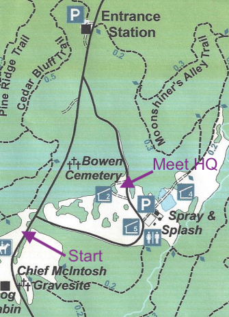
DirectionsPark address and phone: 1046 W McIntosh Cir, Whitesburg, GA 30185, 770-830-5879McIntosh Reserve Park is located 35 miles southwest of Atlanta along the Chattahoochee River and can be reached by U.S. Alternative 27 from Carrollton or Newnan and Georgia Highway 5 from Douglasville. Direct access to the park is provided by a county-maintained road that connects with Georgia Highway 5 at 2 miles west of Whitesburg. Park Office and Entrance GPS: 33.452656, -84.954032 Google Maps Meet HQMeet HQ will be at picnic pavilion #2
Registration & Check inPacket pick up will be available from 11:00 am - 3:00 pm at Meet HQ Packet pick up will continue later from 7:30 pm - 8:00 pm at Host Hotel: Home2 Suites by Hilton Atlanta Newnan, 4051 McIntosh Parkway, Newnan, GA 30263, 770-400-8830 StartsStarts will be from 12:00 noon - 3:00 pm. Maximum Time is 2 hours. Courses close 5 pm
MapsMap is at 1:10,000 scale with 2.5 meter contours, ISOM2017 standard
EmbargoPark is embargoed June 1, 2018
Courses
RestroomsRestrooms are available in the parking area SE of Meet HQ
There are NO restrooms at the park office
There will be ONE portable toilet at the Start callup
Cell Phone Service
Cell phone service is very poor at McIntosh Reserve Park.
Verizon generally has coverage of the entire park, but data coverage can be sparse. AT&T coverage is non-existant in most of the park. Sprint and T-mobile coverage is spotty. Parking
Parking passes must be purchased at the park office upon entering the park
Car parking costs $5. Parking fee is $30 for 15 passenger van Warm up / Practice map
A warm up area will be provided near Meet HQ
A small practice area will be located near Meet HQ. Practice start and finish are at Meet HQ Practice maps will be available at Meet HQ. Model course will be open 11 am-3 pm Practice Map available here. Clothing ReturnNo clothing return is provided because start is close to parking and Meet HQ
Walk to Start
Route will be signposted from Meet HQ
Walk is about 400 m from Meet HQ Control Descriptions
Will be at the call up line
Course NotesMcIntosh Reserve is a 527-acre park that is adjacent to the Chattahoochee river and is the former plantation of Chief William McIntosh. The woods are relatively open although can be thick in a few areas so watching the map is a good idea. The park has less elevation changes than Chattahoochee Bend overall but the 2.5 meter contours do show a variety of reentrants throughout the park. Some complex gully and stream systems will make some legs and controls interesting. Most courses will have to cross a creek at some point which may get the feet wet. In addition, recent rains have caused the mapped intermittent marsh to be slightly wet as well. Picnic tables in the area of the race are unmapped. Map Notes
McIntosh Reserve, bordering the north side of the Chattahoochee River, is mostly ridge and reentrant terrain,
with a few large flat fields thrown in. The map uses symbols set forth in ISOM 2017. Scale for all Middle
courses is 1:10,000, with 2.5m contours. North lines are spaced at 300m. Reserve Punch BoxesIn the rare event that one or more electronic punch units fail, 3 Reserve Punch boxes are provided on the map. Use the pin punch to record your presence at the control
White Course FlaggingTwo legs on the White course are flagged with White vetting tape
|