|
GNC / SEIS
Sat Jan. 19th & Sun Jan. 20th -- Chattahoochee Bend State ParkSite Map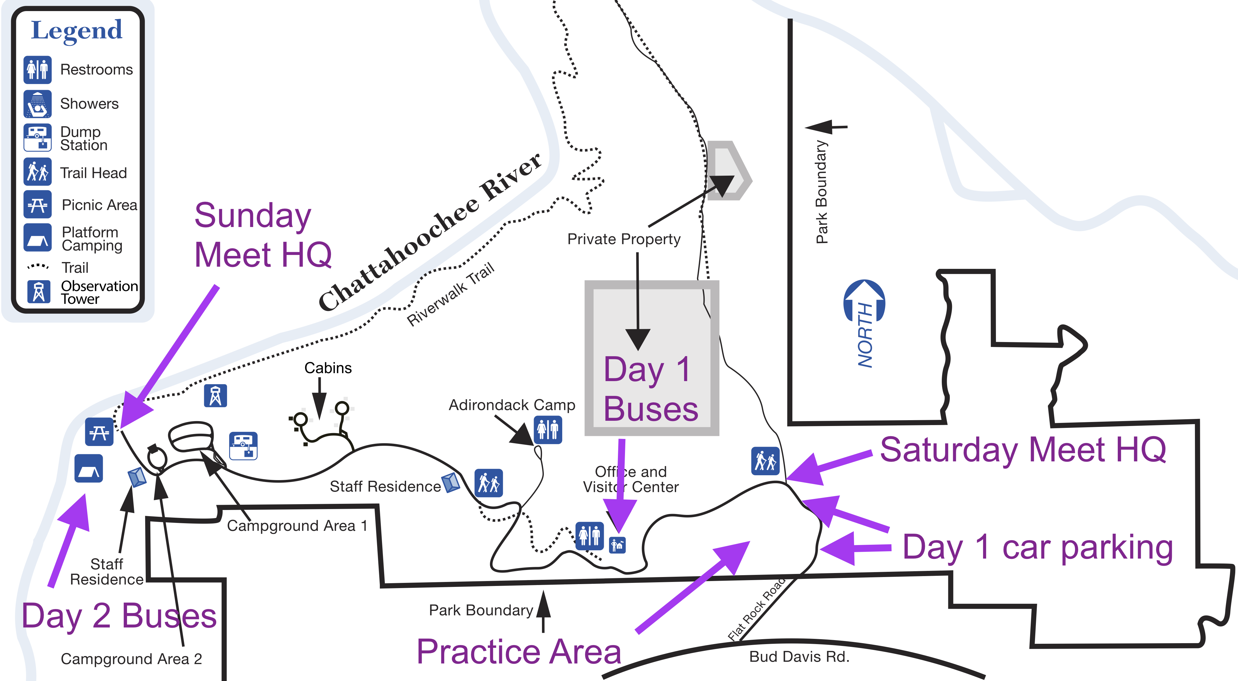
DirectionsPark office address and phone: 425 Bobwhite Way, Newnan, GA 30263, 770-254-7271GPS: 33.422827, -84.982367 Google Maps Registration & Check in
Friday -- Packet pick up will be available from 7:30 pm - 8:00 pm at Host Hotel:
Home2 Suites by Hilton Atlanta Newnan, 4051 McIntosh Parkway, Newnan, GA 30263, 770-400-8830 Saturday -- Packet pick up will be available from 9:00 am - 11:00 am at Meet HQ Sunday -- Packet pick up will be available from 8:00 am - 10:00 am at Meet HQ Saturday Venue Map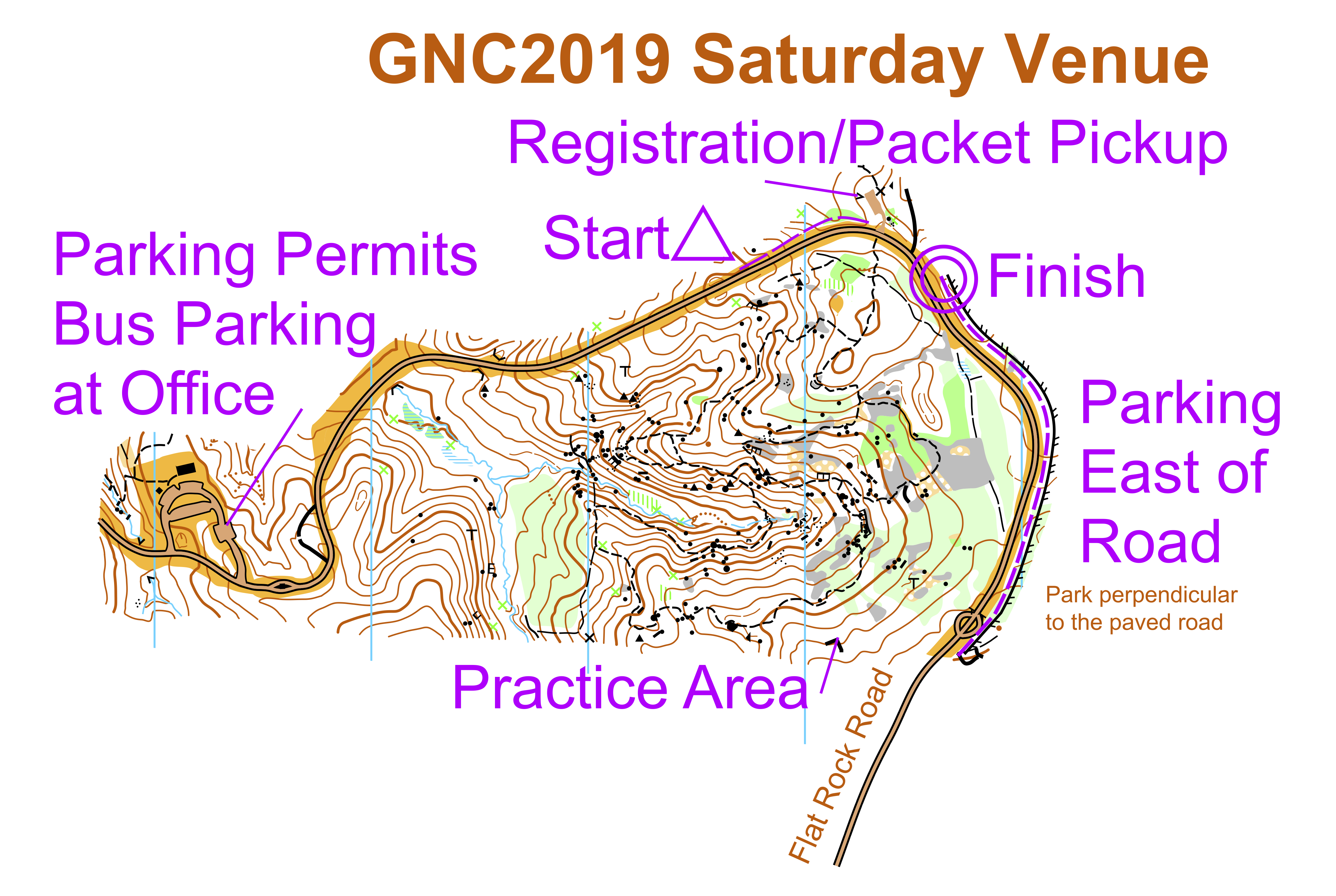
Sunday Venue Map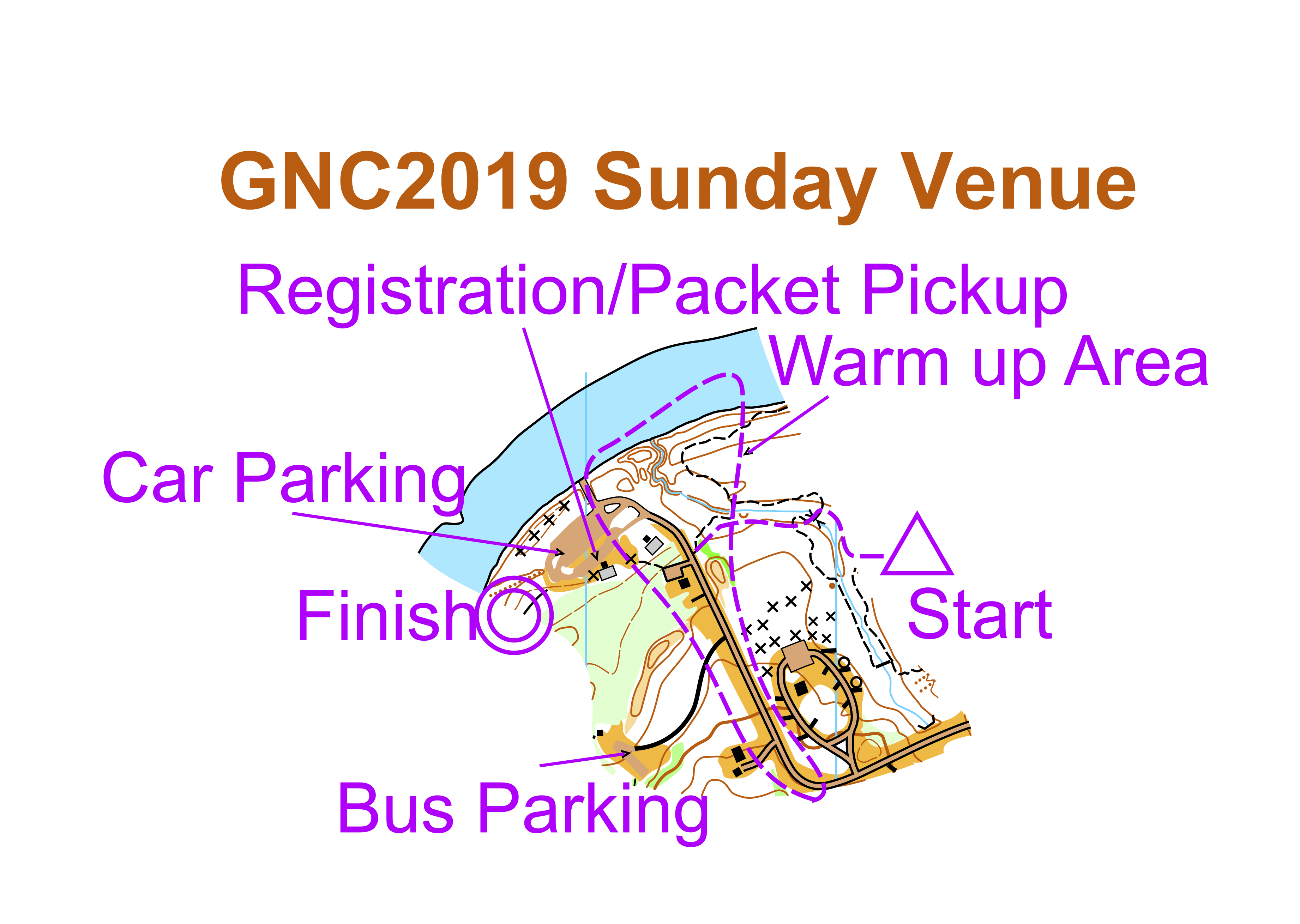
MapsMap is at 1:10,000 scale with 2.5 meter contours, except F-21+ and M-21+ which will be 1:15,000
EmbargoPark is embargoed May 1, 2018
Courses
Jan. 19th and 20th -- Recreational Map Hikes
A limited number of non-competitive Orienteering spaces are available on a beginner's level course.
Beginner instruction will be available. The Map Hike will NOT be the same as any competitive course. Register at the Meet HQ Saturday 10:00 am – 1:00 pm, must return by 3pm, Sunday 10:30 am - noon, return by 2pm. $10 per map, $3 per extra map. Map Hike will use manual punching. Restrooms
Portable toilets are available near Meet HQ on Saturday
A park toilet block is located near Meet HQ on Sunday Toilets are also available at the Park Office and Visitor Center Cell Phone Service
Cell phone service is very poor at Chattahoochee Bend State Park.
Verizon generally has coverage of the entire park, but data coverage can be sparse. AT&T coverage is non-existant in the eastern part of the park and spotty otherwise. Sprint and T-mobile coverage is spotty. Parking
All passenger vehicles must have a state park parking pass. Car parking costs $5/day
Passes will be available at Meet HQ on Saturday. You will need a pass for each day you are in the park You risk a ticket without a parking pass! School buses may park without a pass Parking will be very challenging on Saturday. Please consult the Saturday Venue Map for guidance. Please carpool if you can. Practice Map
A small practice area is located near the Saturday Meet HQ.
Start and finish are across the road from the Saturday Meet HQ.
Practice maps will be available at Registration.
Practice course opens 3 pm Friday Jan 18th and closes noon Sunday Jan 20th.
The Practice course may only be used during daylight hours
Practice Map available here. A small warm up area more convenient for Sunday is indicated on the Sunday Venue Map above.Clothing ReturnClothing will be returned from the start line to Meet HQ regularly
Walk to Start
Routes are marked with blue flagging tape
Saturday walk is about 200 m from Meet HQ Sunday walk is about 400 m from Meet HQ Control Descriptions
Will be at the middle start line
Course NotesSaturday’s Classic competition takes runners over the remnant granite outcrop complex that runs northeast across Georgia and includes Stone Mountain and Panola Mountain and continues into Elberton, famous for its granite monuments. Runners will notice bare rock, small boulders, and ledges, as features used as control points, but may be less than a 1 meter high. Boulders that are visible from 50 meters are mapped regardless their size. There is a wide range of boulder size but to limit the mapped ones to over one meter would reduce the technical interest of orienteering maps covering this granite complex and its characteristic as one of the most ancient terrains in North America, untouched by glaciation. With a contour interval of 2.5 meters, a quick glance at the map and climb may seem daunting, but one should pay attention to the contour shape, as it will be critical navigation information. Holding your line while navigating the rocky detail and greenbrier will be the skill the course setter tests. The Sunday Classic competition is mostly in the flood plain of the Chattahoochee River. Recent rains have flooded most of the bottomland, and the river, in retreat, has left a slippery film of mud on trails and stream banks. Be careful one doesn’t slide into the “Hooch” or one of its many sloughs. Many areas marked as intermittent marsh are bona fide marshes now and that should inform your route choice. Route choices on the intermediate through advanced courses for both days include stream and marsh crossings, so dress accordingly and expect wet feet. Map Notes
Chattahoochee Bend State Park covers an area of low hills that nestle into a big bend of the Chattahoochee River.
Starting from the river and moving inward, there is first a steep, muddy bank that climbs to low sand dunes next
to the river. Between the sand dunes and the hills is a flood plain that is frequently flooded. Low areas are
marshy and muddy and do not drain well or quickly after a flood. The most recent flood was just a few weeks ago.
The flood plain drains where small streams and creeks pass through the dunes into the river.
Further inland from the river is a rocky area (the Flat Rock). The rock is in bands - when you are in a band, there is rock everywhere, and when you are not, there is no rock. On one side of the hills the rocky areas are large boulders and cliffs, but on the other side of the same hill, there will be relatively flat areas of bare rock. These vary in area from the size of a small pond to a lake. The vegetation in the bare rock areas is stunted and green. On the edges of the bare rock there are ankle high prickly pear cactus - the paddles detach and embed in your shoes, and the thorns work their way deeper as you run - ouch!. Frequently there will be light green on the edge of the gray bare rock - don't confuse the gray and green colors! The rest of the park is relatively open, except in the pine areas that were "thinned" back in 2011. Reserve Punch BoxesIn the rare event that one or more electronic punch units fail, 3 Reserve Punch boxes are provided on the map. Use the pin punch to record your presence at the control.White and Yellow Course FlaggingSome legs on the White and Yellow courses are flagged with White vetting tape
|